You are here: Home > Network List > TA - USArray Transportable Network (new EarthScope stations) Stations List
> Station J26L Joseph Creek, AK, USA > Earthquake Result Viewer
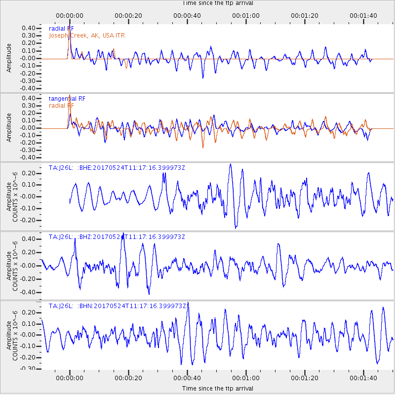
J26L Joseph Creek, AK, USA - Earthquake Result Viewer
*The percent match for this event was below the threshold and hence no stack was calculated.
| Earthquake location: |
Solomon Islands |
| Earthquake latitude/longitude: |
-10.0/161.9 |
| Earthquake time(UTC): |
2017/05/24 (144) 11:05:19 GMT |
| Earthquake Depth: |
55 km |
| Earthquake Magnitude: |
5.5 Mww |
| Earthquake Catalog/Contributor: |
NEIC PDE/us |
|
| Network: |
TA USArray Transportable Network (new EarthScope stations) |
| Station: |
J26L Joseph Creek, AK, USA |
| Lat/Lon: |
64.50 N/143.56 W |
| Elevation: |
1144 m |
|
| Distance: |
84.8 deg |
| Az: |
20.746 deg |
| Baz: |
233.711 deg |
| Ray Param: |
$rayparam |
*The percent match for this event was below the threshold and hence was not used in the summary stack. |
|
| Radial Match: |
65.80377 % |
| Radial Bump: |
400 |
| Transverse Match: |
42.3839 % |
| Transverse Bump: |
400 |
| SOD ConfigId: |
13570011 |
| Insert Time: |
2019-04-28 02:06:25.259 +0000 |
| GWidth: |
2.5 |
| Max Bumps: |
400 |
| Tol: |
0.001 |
|
Signal To Noise
| Channel | StoN | STA | LTA |
| TA:J26L: :BHZ:20170524T11:17:16.399973Z | 3.2371056 | 1.8647366E-7 | 5.7605057E-8 |
| TA:J26L: :BHN:20170524T11:17:16.399973Z | 0.5247695 | 3.7400888E-8 | 7.127108E-8 |
| TA:J26L: :BHE:20170524T11:17:16.399973Z | 1.8313625 | 1.0719851E-7 | 5.853484E-8 |
| Arrivals |
| Ps | |
| PpPs | |
| PsPs/PpSs | |


