You are here: Home > Network List > TA - USArray Transportable Network (new EarthScope stations) Stations List
> Station TPFO Pinon Flats, CA, USA > Earthquake Result Viewer
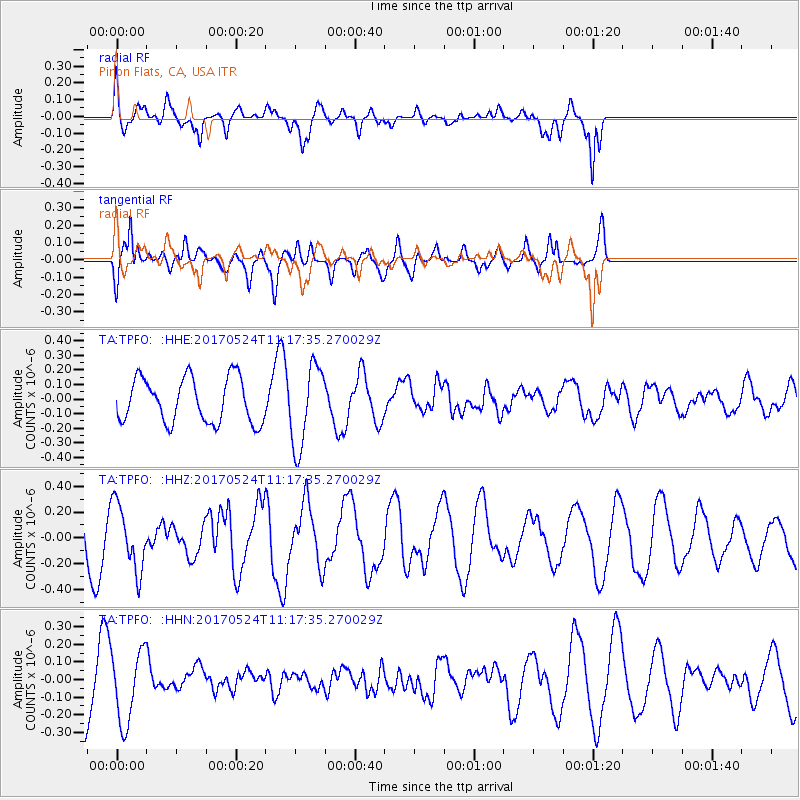
TPFO Pinon Flats, CA, USA - Earthquake Result Viewer
*The percent match for this event was below the threshold and hence no stack was calculated.
| Earthquake location: |
Solomon Islands |
| Earthquake latitude/longitude: |
-10.0/161.9 |
| Earthquake time(UTC): |
2017/05/24 (144) 11:05:19 GMT |
| Earthquake Depth: |
55 km |
| Earthquake Magnitude: |
5.5 Mww |
| Earthquake Catalog/Contributor: |
NEIC PDE/us |
|
| Network: |
TA USArray Transportable Network (new EarthScope stations) |
| Station: |
TPFO Pinon Flats, CA, USA |
| Lat/Lon: |
33.61 N/116.45 W |
| Elevation: |
1275 m |
|
| Distance: |
88.6 deg |
| Az: |
55.694 deg |
| Baz: |
257.133 deg |
| Ray Param: |
$rayparam |
*The percent match for this event was below the threshold and hence was not used in the summary stack. |
|
| Radial Match: |
72.860344 % |
| Radial Bump: |
390 |
| Transverse Match: |
64.75281 % |
| Transverse Bump: |
400 |
| SOD ConfigId: |
13570011 |
| Insert Time: |
2019-04-28 02:06:53.305 +0000 |
| GWidth: |
2.5 |
| Max Bumps: |
400 |
| Tol: |
0.001 |
|
Signal To Noise
| Channel | StoN | STA | LTA |
| TA:TPFO: :HHZ:20170524T11:17:35.270029Z | 1.2819246 | 2.5570125E-7 | 1.9946668E-7 |
| TA:TPFO: :HHN:20170524T11:17:35.270029Z | 1.1120183 | 2.0100629E-7 | 1.8075808E-7 |
| TA:TPFO: :HHE:20170524T11:17:35.270029Z | 1.8216369 | 2.7868373E-7 | 1.5298534E-7 |
| Arrivals |
| Ps | |
| PpPs | |
| PsPs/PpSs | |


