You are here: Home > Network List > CI - Caltech Regional Seismic Network Stations List
> Station MWC Mt. Wilson Observatory, Altadena, CA, USA > Earthquake Result Viewer
MWC Mt. Wilson Observatory, Altadena, CA, USA - Earthquake Result Viewer
| Earthquake location: |
Honduras |
| Earthquake latitude/longitude: |
15.8/-88.3 |
| Earthquake time(UTC): |
1999/07/11 (192) 14:14:16 GMT |
| Earthquake Depth: |
10 km |
| Earthquake Magnitude: |
6.0 MB, 6.6 MS, 6.7 MW, 6.3 ME |
| Earthquake Catalog/Contributor: |
WHDF/NEIC |
|
| Network: |
CI Caltech Regional Seismic Network |
| Station: |
MWC Mt. Wilson Observatory, Altadena, CA, USA |
| Lat/Lon: |
34.22 N/118.06 W |
| Elevation: |
1725 m |
|
| Distance: |
32.4 deg |
| Az: |
309.979 deg |
| Baz: |
117.08 deg |
| Ray Param: |
0.078656726 |
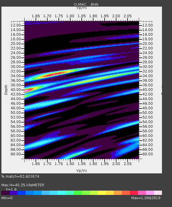
| Estimated Moho Depth: |
40.25 km |
| Estimated Crust Vp/Vs: |
1.60 |
| Assumed Crust Vp: |
6.1 km/s |
| Estimated Crust Vs: |
3.812 km/s |
| Estimated Crust Poisson's Ratio: |
0.18 |
|
| Radial Match: |
92.603874 % |
| Radial Bump: |
381 |
| Transverse Match: |
83.93364 % |
| Transverse Bump: |
400 |
| SOD ConfigId: |
3770 |
| Insert Time: |
2010-02-26 01:13:00.393 +0000 |
| GWidth: |
2.5 |
| Max Bumps: |
400 |
| Tol: |
0.001 |
|

Signal To Noise
| Channel | StoN | STA | LTA |
| CI:MWC: :BHN:19990711T14:20:15.902009Z | 3.0221832 | 3.0254202E-7 | 1.0010711E-7 |
| CI:MWC: :BHE:19990711T14:20:15.902009Z | 5.726403 | 4.468178E-7 | 7.8027654E-8 |
| CI:MWC: :BHZ:19990711T14:20:15.902009Z | 6.612448 | 9.71214E-7 | 1.4687663E-7 |
| Arrivals |
| Ps | 4.3 SECOND |
| PpPs | 16 SECOND |
| PsPs/PpSs | 20 SECOND |


