You are here: Home > Network List > TA - USArray Transportable Network (new EarthScope stations) Stations List
> Station 429A Davenport Ranch, Sheffield, TX, USA > Earthquake Result Viewer
429A Davenport Ranch, Sheffield, TX, USA - Earthquake Result Viewer
| Earthquake location: |
Off Coast Of Ecuador |
| Earthquake latitude/longitude: |
1.4/-85.2 |
| Earthquake time(UTC): |
2009/05/10 (130) 01:16:06 GMT |
| Earthquake Depth: |
6.0 km |
| Earthquake Magnitude: |
5.5 MB, 5.7 MS, 6.1 MW, 6.1 MW |
| Earthquake Catalog/Contributor: |
WHDF/NEIC |
|
| Network: |
TA USArray Transportable Network (new EarthScope stations) |
| Station: |
429A Davenport Ranch, Sheffield, TX, USA |
| Lat/Lon: |
30.62 N/101.89 W |
| Elevation: |
804 m |
|
| Distance: |
33.1 deg |
| Az: |
332.997 deg |
| Baz: |
148.227 deg |
| Ray Param: |
0.07836396 |
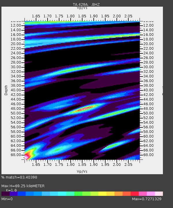
| Estimated Moho Depth: |
69.25 km |
| Estimated Crust Vp/Vs: |
1.60 |
| Assumed Crust Vp: |
6.38 km/s |
| Estimated Crust Vs: |
3.988 km/s |
| Estimated Crust Poisson's Ratio: |
0.18 |
|
| Radial Match: |
83.40398 % |
| Radial Bump: |
377 |
| Transverse Match: |
60.782772 % |
| Transverse Bump: |
400 |
| SOD ConfigId: |
2760 |
| Insert Time: |
2010-03-06 00:06:20.826 +0000 |
| GWidth: |
2.5 |
| Max Bumps: |
400 |
| Tol: |
0.001 |
|

Signal To Noise
| Channel | StoN | STA | LTA |
| TA:429A: :BHZ:20090510T01:22:12.975015Z | 3.3551564 | 5.046678E-7 | 1.5041559E-7 |
| TA:429A: :BHN:20090510T01:22:12.975015Z | 2.1964219 | 1.8206657E-7 | 8.2892356E-8 |
| TA:429A: :BHE:20090510T01:22:12.975015Z | 1.8783956 | 1.4930247E-7 | 7.948404E-8 |
| Arrivals |
| Ps | 7.1 SECOND |
| PpPs | 26 SECOND |
| PsPs/PpSs | 33 SECOND |


