You are here: Home > Network List > CI - Caltech Regional Seismic Network Stations List
> Station MPM Manuel Prospect Mine, California, USA > Earthquake Result Viewer
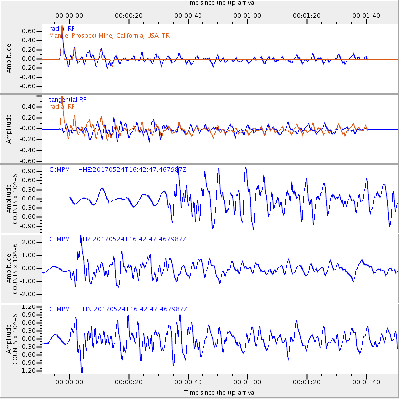
MPM Manuel Prospect Mine, California, USA - Earthquake Result Viewer
*The percent match for this event was below the threshold and hence no stack was calculated.
| Earthquake location: |
Fox Islands, Aleutian Islands |
| Earthquake latitude/longitude: |
52.4/-166.7 |
| Earthquake time(UTC): |
2017/05/24 (144) 16:36:01 GMT |
| Earthquake Depth: |
2.0 km |
| Earthquake Magnitude: |
5.7 Mi |
| Earthquake Catalog/Contributor: |
NEIC PDE/at |
|
| Network: |
CI Caltech Regional Seismic Network |
| Station: |
MPM Manuel Prospect Mine, California, USA |
| Lat/Lon: |
36.06 N/117.49 W |
| Elevation: |
185 m |
|
| Distance: |
38.1 deg |
| Az: |
95.537 deg |
| Baz: |
311.209 deg |
| Ray Param: |
$rayparam |
*The percent match for this event was below the threshold and hence was not used in the summary stack. |
|
| Radial Match: |
74.03469 % |
| Radial Bump: |
400 |
| Transverse Match: |
73.924515 % |
| Transverse Bump: |
400 |
| SOD ConfigId: |
13570011 |
| Insert Time: |
2019-04-28 02:09:26.319 +0000 |
| GWidth: |
2.5 |
| Max Bumps: |
400 |
| Tol: |
0.001 |
|
Signal To Noise
| Channel | StoN | STA | LTA |
| CI:MPM: :HHZ:20170524T16:42:47.467987Z | 5.8653255 | 1.0604588E-6 | 1.8080136E-7 |
| CI:MPM: :HHN:20170524T16:42:47.467987Z | 3.3557773 | 5.4943735E-7 | 1.6372879E-7 |
| CI:MPM: :HHE:20170524T16:42:47.467987Z | 3.449918 | 4.6084054E-7 | 1.3358014E-7 |
| Arrivals |
| Ps | |
| PpPs | |
| PsPs/PpSs | |


