You are here: Home > Network List > G - GEOSCOPE Stations List
> Station NOUC Port Laguerre, New Caledonia > Earthquake Result Viewer
NOUC Port Laguerre, New Caledonia - Earthquake Result Viewer
| Earthquake location: |
Banda Sea |
| Earthquake latitude/longitude: |
-4.1/129.5 |
| Earthquake time(UTC): |
2015/12/09 (343) 10:21:50 GMT |
| Earthquake Depth: |
34 km |
| Earthquake Magnitude: |
6.9 MWP |
| Earthquake Catalog/Contributor: |
NEIC PDE/NEIC COMCAT |
|
| Network: |
G GEOSCOPE |
| Station: |
NOUC Port Laguerre, New Caledonia |
| Lat/Lon: |
22.10 S/166.30 E |
| Elevation: |
112 m |
|
| Distance: |
39.9 deg |
| Az: |
119.941 deg |
| Baz: |
291.252 deg |
| Ray Param: |
0.074640825 |
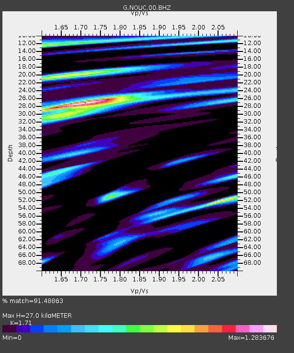
| Estimated Moho Depth: |
27.0 km |
| Estimated Crust Vp/Vs: |
1.71 |
| Assumed Crust Vp: |
5.14 km/s |
| Estimated Crust Vs: |
3.006 km/s |
| Estimated Crust Poisson's Ratio: |
0.24 |
|
| Radial Match: |
91.48863 % |
| Radial Bump: |
324 |
| Transverse Match: |
87.0023 % |
| Transverse Bump: |
372 |
| SOD ConfigId: |
1259291 |
| Insert Time: |
2015-12-23 10:31:52.493 +0000 |
| GWidth: |
2.5 |
| Max Bumps: |
400 |
| Tol: |
0.001 |
|
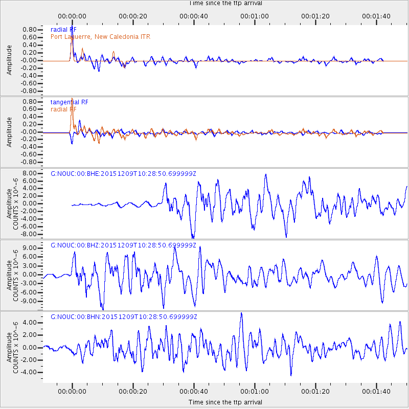
Signal To Noise
| Channel | StoN | STA | LTA |
| G:NOUC:00:BHZ:20151209T10:28:50.699999Z | 10.344526 | 3.5620196E-6 | 3.443386E-7 |
| G:NOUC:00:BHN:20151209T10:28:50.699999Z | 2.7653456 | 9.577267E-7 | 3.463317E-7 |
| G:NOUC:00:BHE:20151209T10:28:50.699999Z | 6.724051 | 2.3459245E-6 | 3.4888558E-7 |
| Arrivals |
| Ps | 3.9 SECOND |
| PpPs | 14 SECOND |
| PsPs/PpSs | 18 SECOND |


