You are here: Home > Network List > TA - USArray Transportable Network (new EarthScope stations) Stations List
> Station 429A Davenport Ranch, Sheffield, TX, USA > Earthquake Result Viewer
429A Davenport Ranch, Sheffield, TX, USA - Earthquake Result Viewer
| Earthquake location: |
Hokkaido, Japan Region |
| Earthquake latitude/longitude: |
41.8/143.4 |
| Earthquake time(UTC): |
2009/06/05 (156) 03:30:33 GMT |
| Earthquake Depth: |
29 km |
| Earthquake Magnitude: |
6.0 MB, 6.3 MS, 6.4 MW, 6.4 MW |
| Earthquake Catalog/Contributor: |
WHDF/NEIC |
|
| Network: |
TA USArray Transportable Network (new EarthScope stations) |
| Station: |
429A Davenport Ranch, Sheffield, TX, USA |
| Lat/Lon: |
30.62 N/101.89 W |
| Elevation: |
804 m |
|
| Distance: |
86.1 deg |
| Az: |
51.74 deg |
| Baz: |
317.092 deg |
| Ray Param: |
0.044253543 |
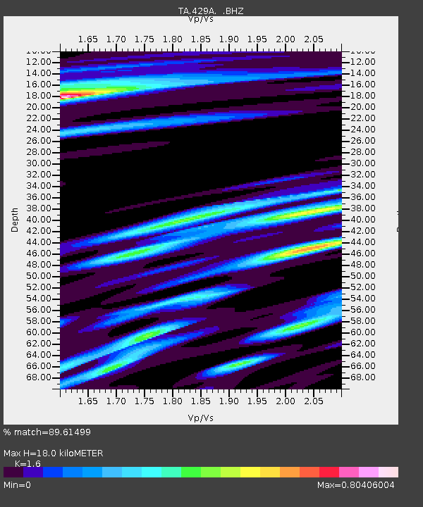
| Estimated Moho Depth: |
18.0 km |
| Estimated Crust Vp/Vs: |
1.60 |
| Assumed Crust Vp: |
6.38 km/s |
| Estimated Crust Vs: |
3.988 km/s |
| Estimated Crust Poisson's Ratio: |
0.18 |
|
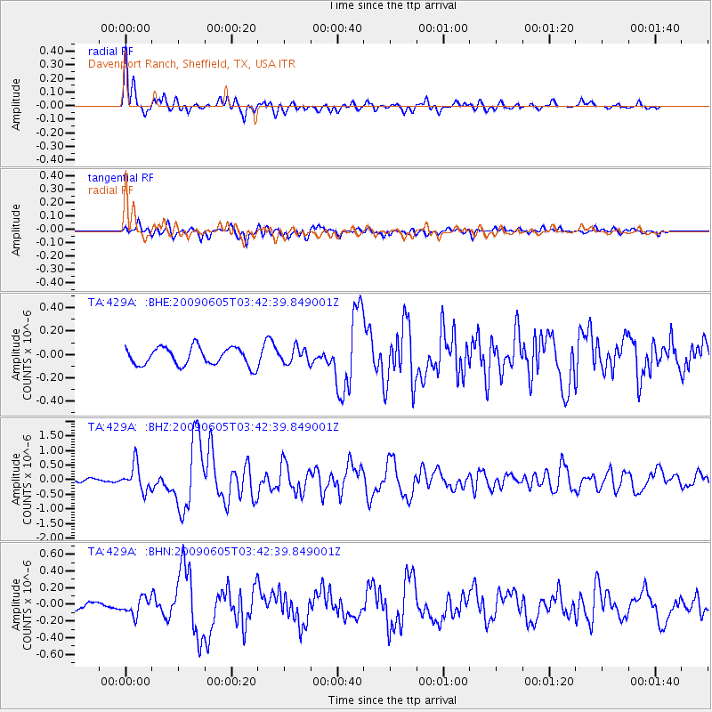
| Radial Match: |
89.61499 % |
| Radial Bump: |
400 |
| Transverse Match: |
76.90405 % |
| Transverse Bump: |
400 |
| SOD ConfigId: |
2648 |
| Insert Time: |
2010-03-06 00:06:40.094 +0000 |
| GWidth: |
2.5 |
| Max Bumps: |
400 |
| Tol: |
0.001 |
|
Signal To Noise
| Channel | StoN | STA | LTA |
| TA:429A: :BHZ:20090605T03:42:39.849001Z | 7.1911116 | 4.5282655E-7 | 6.2970315E-8 |
| TA:429A: :BHN:20090605T03:42:39.849001Z | 1.7376634 | 1.02718126E-7 | 5.911279E-8 |
| TA:429A: :BHE:20090605T03:42:39.849001Z | 0.8787536 | 6.650146E-8 | 7.567702E-8 |
| Arrivals |
| Ps | 1.7 SECOND |
| PpPs | 7.1 SECOND |
| PsPs/PpSs | 8.9 SECOND |


