You are here: Home > Network List > TA - USArray Transportable Network (new EarthScope stations) Stations List
> Station 429A Davenport Ranch, Sheffield, TX, USA > Earthquake Result Viewer
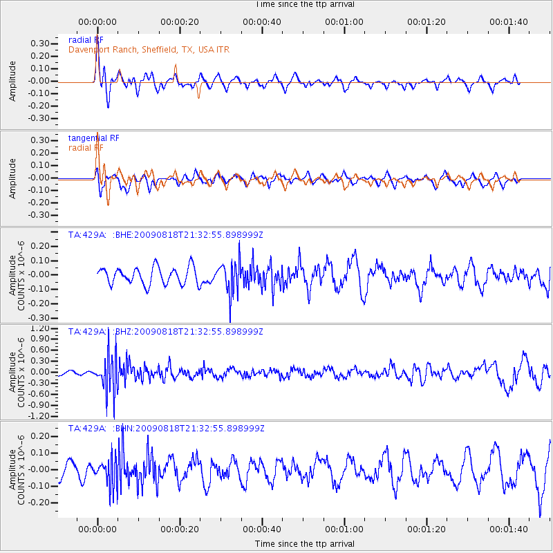
429A Davenport Ranch, Sheffield, TX, USA - Earthquake Result Viewer
*The percent match for this event was below the threshold and hence no stack was calculated.
| Earthquake location: |
South Of Fiji Islands |
| Earthquake latitude/longitude: |
-26.1/-178.4 |
| Earthquake time(UTC): |
2009/08/18 (230) 21:20:47 GMT |
| Earthquake Depth: |
270 km |
| Earthquake Magnitude: |
5.5 MB, 6.3 MW, 6.3 MW |
| Earthquake Catalog/Contributor: |
WHDF/NEIC |
|
| Network: |
TA USArray Transportable Network (new EarthScope stations) |
| Station: |
429A Davenport Ranch, Sheffield, TX, USA |
| Lat/Lon: |
30.62 N/101.89 W |
| Elevation: |
804 m |
|
| Distance: |
92.3 deg |
| Az: |
57.022 deg |
| Baz: |
241.083 deg |
| Ray Param: |
$rayparam |
*The percent match for this event was below the threshold and hence was not used in the summary stack. |
|
| Radial Match: |
65.554794 % |
| Radial Bump: |
400 |
| Transverse Match: |
47.199043 % |
| Transverse Bump: |
400 |
| SOD ConfigId: |
2622 |
| Insert Time: |
2010-03-06 00:06:57.751 +0000 |
| GWidth: |
2.5 |
| Max Bumps: |
400 |
| Tol: |
0.001 |
|
Signal To Noise
| Channel | StoN | STA | LTA |
| TA:429A: :BHZ:20090818T21:32:55.898999Z | 5.7093525 | 4.914887E-7 | 8.6084846E-8 |
| TA:429A: :BHN:20090818T21:32:55.898999Z | 1.5022621 | 8.2472255E-8 | 5.4898713E-8 |
| TA:429A: :BHE:20090818T21:32:55.898999Z | 1.8906317 | 1.10237806E-7 | 5.8307393E-8 |
| Arrivals |
| Ps | |
| PpPs | |
| PsPs/PpSs | |


