You are here: Home > Network List > IU - Global Seismograph Network (GSN - IRIS/USGS) Stations List
> Station JOHN Johnston Island, USA > Earthquake Result Viewer
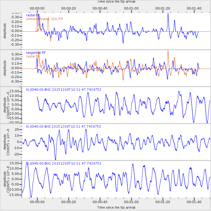
JOHN Johnston Island, USA - Earthquake Result Viewer
*The percent match for this event was below the threshold and hence no stack was calculated.
| Earthquake location: |
Banda Sea |
| Earthquake latitude/longitude: |
-4.1/129.5 |
| Earthquake time(UTC): |
2015/12/09 (343) 10:21:50 GMT |
| Earthquake Depth: |
34 km |
| Earthquake Magnitude: |
6.9 MWP |
| Earthquake Catalog/Contributor: |
NEIC PDE/NEIC COMCAT |
|
| Network: |
IU Global Seismograph Network (GSN - IRIS/USGS) |
| Station: |
JOHN Johnston Island, USA |
| Lat/Lon: |
16.73 N/169.53 W |
| Elevation: |
2.0 m |
|
| Distance: |
63.7 deg |
| Az: |
69.186 deg |
| Baz: |
256.666 deg |
| Ray Param: |
$rayparam |
*The percent match for this event was below the threshold and hence was not used in the summary stack. |
|
| Radial Match: |
47.799652 % |
| Radial Bump: |
296 |
| Transverse Match: |
48.41945 % |
| Transverse Bump: |
400 |
| SOD ConfigId: |
1259291 |
| Insert Time: |
2015-12-23 10:33:42.538 +0000 |
| GWidth: |
2.5 |
| Max Bumps: |
400 |
| Tol: |
0.001 |
|
Signal To Noise
| Channel | StoN | STA | LTA |
| IU:JOHN:00:BHZ:20151209T10:31:47.743975Z | 1.3888291 | 4.278185E-6 | 3.0804256E-6 |
| IU:JOHN:00:BH1:20151209T10:31:47.743975Z | 0.86056566 | 5.754158E-6 | 6.686483E-6 |
| IU:JOHN:00:BH2:20151209T10:31:47.743975Z | 2.624277 | 9.6036E-6 | 3.659522E-6 |
| Arrivals |
| Ps | |
| PpPs | |
| PsPs/PpSs | |


