You are here: Home > Network List > TA - USArray Transportable Network (new EarthScope stations) Stations List
> Station 732A Laxson Ranch, Crystal City, TX, USA > Earthquake Result Viewer
732A Laxson Ranch, Crystal City, TX, USA - Earthquake Result Viewer
| Earthquake location: |
Near Coast Of Venezuela |
| Earthquake latitude/longitude: |
10.7/-67.9 |
| Earthquake time(UTC): |
2009/09/12 (255) 20:06:24 GMT |
| Earthquake Depth: |
10 km |
| Earthquake Magnitude: |
6.3 MB, 6.4 MS, 6.3 MW, 6.3 MW |
| Earthquake Catalog/Contributor: |
WHDF/NEIC |
|
| Network: |
TA USArray Transportable Network (new EarthScope stations) |
| Station: |
732A Laxson Ranch, Crystal City, TX, USA |
| Lat/Lon: |
28.73 N/99.97 W |
| Elevation: |
178 m |
|
| Distance: |
34.9 deg |
| Az: |
305.513 deg |
| Baz: |
114.37 deg |
| Ray Param: |
0.07748747 |
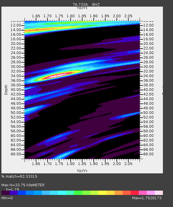
| Estimated Moho Depth: |
33.75 km |
| Estimated Crust Vp/Vs: |
1.74 |
| Assumed Crust Vp: |
6.347 km/s |
| Estimated Crust Vs: |
3.648 km/s |
| Estimated Crust Poisson's Ratio: |
0.25 |
|
| Radial Match: |
92.33315 % |
| Radial Bump: |
297 |
| Transverse Match: |
65.440765 % |
| Transverse Bump: |
400 |
| SOD ConfigId: |
2622 |
| Insert Time: |
2010-03-06 00:07:36.676 +0000 |
| GWidth: |
2.5 |
| Max Bumps: |
400 |
| Tol: |
0.001 |
|
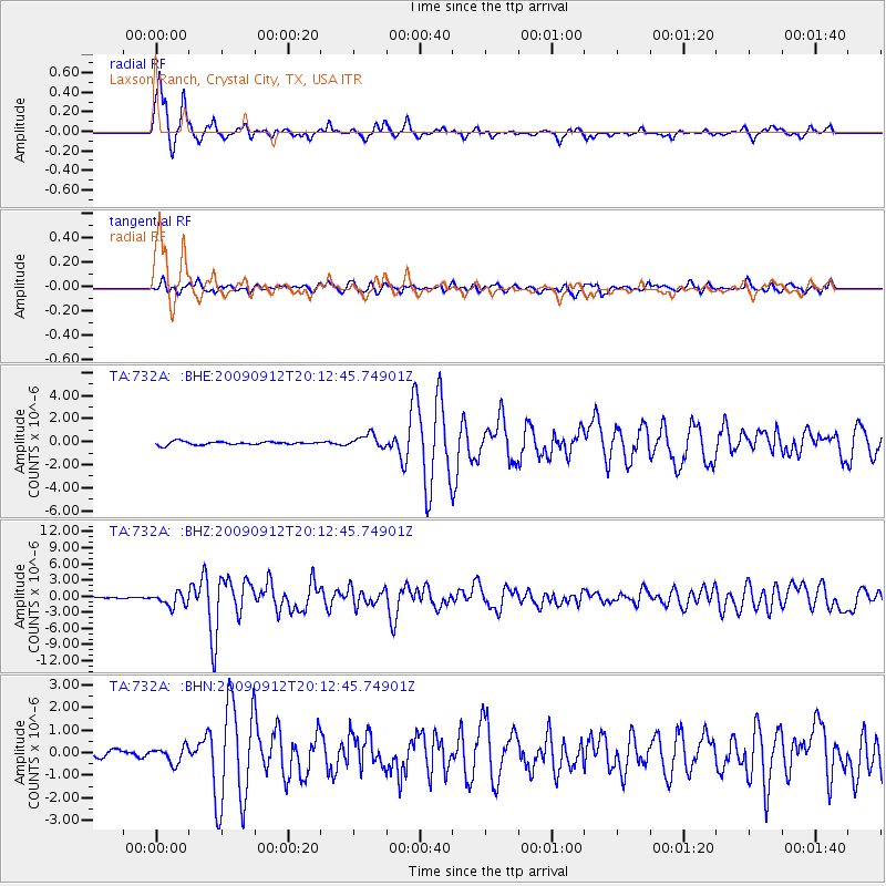
Signal To Noise
| Channel | StoN | STA | LTA |
| TA:732A: :BHZ:20090912T20:12:45.74901Z | 13.038101 | 1.2616774E-6 | 9.6768495E-8 |
| TA:732A: :BHN:20090912T20:12:45.74901Z | 2.9305837 | 3.508748E-7 | 1.1972864E-7 |
| TA:732A: :BHE:20090912T20:12:45.74901Z | 4.0643134 | 5.709255E-7 | 1.4047279E-7 |
| Arrivals |
| Ps | 4.2 SECOND |
| PpPs | 14 SECOND |
| PsPs/PpSs | 18 SECOND |


