You are here: Home > Network List > TA - USArray Transportable Network (new EarthScope stations) Stations List
> Station 732A Laxson Ranch, Crystal City, TX, USA > Earthquake Result Viewer
732A Laxson Ranch, Crystal City, TX, USA - Earthquake Result Viewer
| Earthquake location: |
Peru-Bolivia Border Region |
| Earthquake latitude/longitude: |
-15.6/-69.3 |
| Earthquake time(UTC): |
2009/09/30 (273) 19:03:17 GMT |
| Earthquake Depth: |
255 km |
| Earthquake Magnitude: |
5.9 MB, 5.8 MW |
| Earthquake Catalog/Contributor: |
WHDF/NEIC |
|
| Network: |
TA USArray Transportable Network (new EarthScope stations) |
| Station: |
732A Laxson Ranch, Crystal City, TX, USA |
| Lat/Lon: |
28.73 N/99.97 W |
| Elevation: |
178 m |
|
| Distance: |
53.1 deg |
| Az: |
325.913 deg |
| Baz: |
142.042 deg |
| Ray Param: |
0.06540209 |
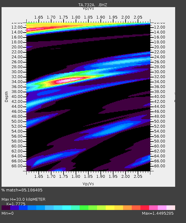
| Estimated Moho Depth: |
33.0 km |
| Estimated Crust Vp/Vs: |
1.78 |
| Assumed Crust Vp: |
6.347 km/s |
| Estimated Crust Vs: |
3.571 km/s |
| Estimated Crust Poisson's Ratio: |
0.27 |
|
| Radial Match: |
85.186485 % |
| Radial Bump: |
400 |
| Transverse Match: |
75.48054 % |
| Transverse Bump: |
400 |
| SOD ConfigId: |
2622 |
| Insert Time: |
2010-03-06 00:07:40.923 +0000 |
| GWidth: |
2.5 |
| Max Bumps: |
400 |
| Tol: |
0.001 |
|

Signal To Noise
| Channel | StoN | STA | LTA |
| TA:732A: :BHZ:20090930T19:11:37.875012Z | 56.374134 | 5.616897E-6 | 9.963606E-8 |
| TA:732A: :BHN:20090930T19:11:37.875012Z | 11.374261 | 1.0877932E-6 | 9.563638E-8 |
| TA:732A: :BHE:20090930T19:11:37.875012Z | 5.8234534 | 8.593889E-7 | 1.4757374E-7 |
| Arrivals |
| Ps | 4.3 SECOND |
| PpPs | 14 SECOND |
| PsPs/PpSs | 18 SECOND |


