You are here: Home > Network List > TA - USArray Transportable Network (new EarthScope stations) Stations List
> Station 732A Laxson Ranch, Crystal City, TX, USA > Earthquake Result Viewer
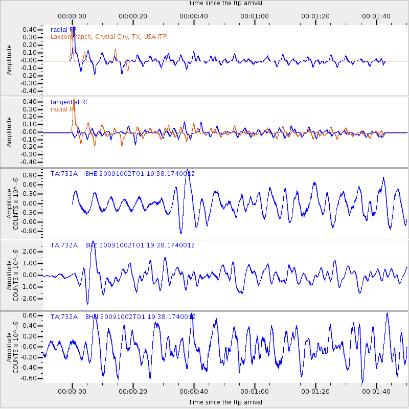
732A Laxson Ranch, Crystal City, TX, USA - Earthquake Result Viewer

| Earthquake location: |
Tonga Islands |
| Earthquake latitude/longitude: |
-16.3/-173.5 |
| Earthquake time(UTC): |
2009/10/02 (275) 01:07:39 GMT |
| Earthquake Depth: |
8.0 km |
| Earthquake Magnitude: |
6.1 MB, 6.0 MS, 6.1 MW, 6.1 MW |
| Earthquake Catalog/Contributor: |
WHDF/NEIC |
|
| Network: |
TA USArray Transportable Network (new EarthScope stations) |
| Station: |
732A Laxson Ranch, Crystal City, TX, USA |
| Lat/Lon: |
28.73 N/99.97 W |
| Elevation: |
178 m |
|
| Distance: |
83.9 deg |
| Az: |
57.87 deg |
| Baz: |
247.79 deg |
| Ray Param: |
0.04584471 |
| Estimated Moho Depth: |
13.0 km |
| Estimated Crust Vp/Vs: |
1.87 |
| Assumed Crust Vp: |
6.347 km/s |
| Estimated Crust Vs: |
3.403 km/s |
| Estimated Crust Poisson's Ratio: |
0.30 |
|
| Radial Match: |
81.9092 % |
| Radial Bump: |
273 |
| Transverse Match: |
64.84125 % |
| Transverse Bump: |
323 |
| SOD ConfigId: |
2622 |
| Insert Time: |
2010-03-06 00:07:43.484 +0000 |
| GWidth: |
2.5 |
| Max Bumps: |
400 |
| Tol: |
0.001 |
|
Signal To Noise
| Channel | StoN | STA | LTA |
| TA:732A: :BHZ:20091002T01:19:38.174001Z | 6.9372416 | 5.615484E-7 | 8.0946926E-8 |
| TA:732A: :BHN:20091002T01:19:38.174001Z | 0.78377336 | 1.09911234E-7 | 1.4023344E-7 |
| TA:732A: :BHE:20091002T01:19:38.174001Z | 1.4644086 | 2.695353E-7 | 1.8405744E-7 |
| Arrivals |
| Ps | 1.8 SECOND |
| PpPs | 5.7 SECOND |
| PsPs/PpSs | 7.5 SECOND |


