You are here: Home > Network List > CI - Caltech Regional Seismic Network Stations List
> Station MWC Mt. Wilson Observatory, Altadena, CA, USA > Earthquake Result Viewer
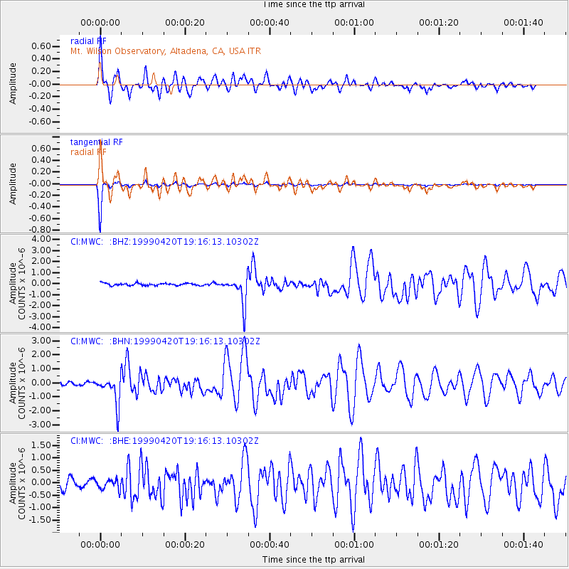
MWC Mt. Wilson Observatory, Altadena, CA, USA - Earthquake Result Viewer

| Earthquake location: |
Kermadec Islands Region |
| Earthquake latitude/longitude: |
-31.9/-179.0 |
| Earthquake time(UTC): |
1999/04/20 (110) 19:04:08 GMT |
| Earthquake Depth: |
96 km |
| Earthquake Magnitude: |
6.2 MB, 6.5 MW, 6.5 MW |
| Earthquake Catalog/Contributor: |
WHDF/NEIC |
|
| Network: |
CI Caltech Regional Seismic Network |
| Station: |
MWC Mt. Wilson Observatory, Altadena, CA, USA |
| Lat/Lon: |
34.22 N/118.06 W |
| Elevation: |
1725 m |
|
| Distance: |
87.3 deg |
| Az: |
46.502 deg |
| Baz: |
228.135 deg |
| Ray Param: |
0.043252923 |
| Estimated Moho Depth: |
23.0 km |
| Estimated Crust Vp/Vs: |
1.88 |
| Assumed Crust Vp: |
6.1 km/s |
| Estimated Crust Vs: |
3.24 km/s |
| Estimated Crust Poisson's Ratio: |
0.30 |
|
| Radial Match: |
93.17234 % |
| Radial Bump: |
400 |
| Transverse Match: |
98.760735 % |
| Transverse Bump: |
184 |
| SOD ConfigId: |
3770 |
| Insert Time: |
2010-02-26 01:13:06.200 +0000 |
| GWidth: |
2.5 |
| Max Bumps: |
400 |
| Tol: |
0.001 |
|
Signal To Noise
| Channel | StoN | STA | LTA |
| CI:MWC: :BHN:19990420T19:16:13.10302Z | 9.05658 | 1.0573264E-6 | 1.1674676E-7 |
| CI:MWC: :BHE:19990420T19:16:13.10302Z | 0.99740076 | 2.0302832E-7 | 2.035574E-7 |
| CI:MWC: :BHZ:19990420T19:16:13.10302Z | 13.025965 | 1.3225333E-6 | 1.01530546E-7 |
| Arrivals |
| Ps | 3.4 SECOND |
| PpPs | 11 SECOND |
| PsPs/PpSs | 14 SECOND |


