You are here: Home > Network List > TA - USArray Transportable Network (new EarthScope stations) Stations List
> Station 732A Laxson Ranch, Crystal City, TX, USA > Earthquake Result Viewer
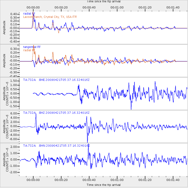
732A Laxson Ranch, Crystal City, TX, USA - Earthquake Result Viewer

| Earthquake location: |
Kuril Islands |
| Earthquake latitude/longitude: |
50.8/155.0 |
| Earthquake time(UTC): |
2009/04/21 (111) 05:26:11 GMT |
| Earthquake Depth: |
152 km |
| Earthquake Magnitude: |
6.0 MB, 6.2 MW, 6.2 MW |
| Earthquake Catalog/Contributor: |
WHDF/NEIC |
|
| Network: |
TA USArray Transportable Network (new EarthScope stations) |
| Station: |
732A Laxson Ranch, Crystal City, TX, USA |
| Lat/Lon: |
28.73 N/99.97 W |
| Elevation: |
178 m |
|
| Distance: |
77.0 deg |
| Az: |
60.535 deg |
| Baz: |
321.05 deg |
| Ray Param: |
0.05026072 |
| Estimated Moho Depth: |
33.75 km |
| Estimated Crust Vp/Vs: |
1.75 |
| Assumed Crust Vp: |
6.347 km/s |
| Estimated Crust Vs: |
3.617 km/s |
| Estimated Crust Poisson's Ratio: |
0.26 |
|
| Radial Match: |
93.95794 % |
| Radial Bump: |
358 |
| Transverse Match: |
81.178085 % |
| Transverse Bump: |
400 |
| SOD ConfigId: |
2658 |
| Insert Time: |
2010-03-06 00:07:57.264 +0000 |
| GWidth: |
2.5 |
| Max Bumps: |
400 |
| Tol: |
0.001 |
|
Signal To Noise
| Channel | StoN | STA | LTA |
| TA:732A: :BHZ:20090421T05:37:16.324016Z | 30.019333 | 1.9356398E-6 | 6.447977E-8 |
| TA:732A: :BHN:20090421T05:37:16.324016Z | 6.277436 | 5.606031E-7 | 8.930448E-8 |
| TA:732A: :BHE:20090421T05:37:16.324016Z | 6.937048 | 5.1292426E-7 | 7.3939844E-8 |
| Arrivals |
| Ps | 4.1 SECOND |
| PpPs | 14 SECOND |
| PsPs/PpSs | 18 SECOND |


