You are here: Home > Network List > TA - USArray Transportable Network (new EarthScope stations) Stations List
> Station L44A Lake County Forest Preserve, Grayslake, IL, USA > Earthquake Result Viewer
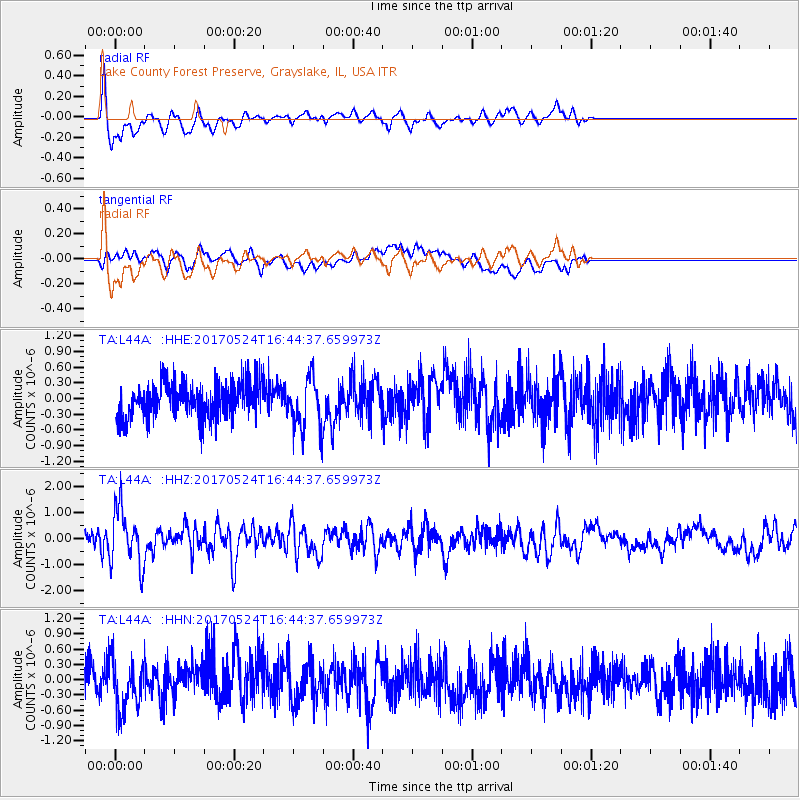
L44A Lake County Forest Preserve, Grayslake, IL, USA - Earthquake Result Viewer
*The percent match for this event was below the threshold and hence no stack was calculated.
| Earthquake location: |
Fox Islands, Aleutian Islands |
| Earthquake latitude/longitude: |
52.4/-166.7 |
| Earthquake time(UTC): |
2017/05/24 (144) 16:36:01 GMT |
| Earthquake Depth: |
2.0 km |
| Earthquake Magnitude: |
5.7 Mi |
| Earthquake Catalog/Contributor: |
NEIC PDE/at |
|
| Network: |
TA USArray Transportable Network (new EarthScope stations) |
| Station: |
L44A Lake County Forest Preserve, Grayslake, IL, USA |
| Lat/Lon: |
42.18 N/87.91 W |
| Elevation: |
202 m |
|
| Distance: |
51.9 deg |
| Az: |
67.936 deg |
| Baz: |
310.215 deg |
| Ray Param: |
$rayparam |
*The percent match for this event was below the threshold and hence was not used in the summary stack. |
|
| Radial Match: |
75.95178 % |
| Radial Bump: |
400 |
| Transverse Match: |
52.708515 % |
| Transverse Bump: |
400 |
| SOD ConfigId: |
13570011 |
| Insert Time: |
2019-04-28 02:16:52.105 +0000 |
| GWidth: |
2.5 |
| Max Bumps: |
400 |
| Tol: |
0.001 |
|
Signal To Noise
| Channel | StoN | STA | LTA |
| TA:L44A: :HHZ:20170524T16:44:37.659973Z | 3.5042224 | 1.0760299E-6 | 3.0706667E-7 |
| TA:L44A: :HHN:20170524T16:44:37.659973Z | 1.5413167 | 4.9236905E-7 | 3.1944703E-7 |
| TA:L44A: :HHE:20170524T16:44:37.659973Z | 1.7747825 | 5.615248E-7 | 3.1639078E-7 |
| Arrivals |
| Ps | |
| PpPs | |
| PsPs/PpSs | |


