You are here: Home > Network List > TA - USArray Transportable Network (new EarthScope stations) Stations List
> Station 532A Rocksprings, TX, USA > Earthquake Result Viewer
532A Rocksprings, TX, USA - Earthquake Result Viewer
| Earthquake location: |
Tonga Islands |
| Earthquake latitude/longitude: |
-20.8/-174.3 |
| Earthquake time(UTC): |
2009/07/30 (211) 20:05:34 GMT |
| Earthquake Depth: |
10 km |
| Earthquake Magnitude: |
5.9 MB, 5.7 MS, 5.8 MW, 5.7 MW |
| Earthquake Catalog/Contributor: |
WHDF/NEIC |
|
| Network: |
TA USArray Transportable Network (new EarthScope stations) |
| Station: |
532A Rocksprings, TX, USA |
| Lat/Lon: |
30.13 N/99.90 W |
| Elevation: |
703 m |
|
| Distance: |
87.6 deg |
| Az: |
56.613 deg |
| Baz: |
244.346 deg |
| Ray Param: |
0.043211654 |
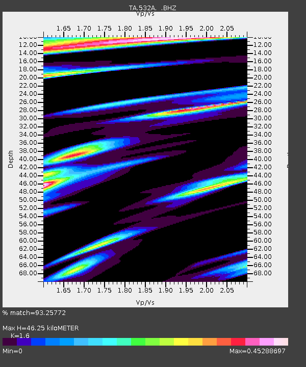
| Estimated Moho Depth: |
46.25 km |
| Estimated Crust Vp/Vs: |
1.60 |
| Assumed Crust Vp: |
6.498 km/s |
| Estimated Crust Vs: |
4.061 km/s |
| Estimated Crust Poisson's Ratio: |
0.18 |
|
| Radial Match: |
93.25772 % |
| Radial Bump: |
366 |
| Transverse Match: |
86.43927 % |
| Transverse Bump: |
354 |
| SOD ConfigId: |
2622 |
| Insert Time: |
2010-03-06 00:08:56.030 +0000 |
| GWidth: |
2.5 |
| Max Bumps: |
400 |
| Tol: |
0.001 |
|
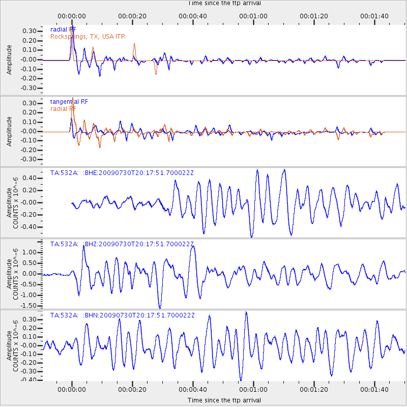
Signal To Noise
| Channel | StoN | STA | LTA |
| TA:532A: :BHZ:20090730T20:17:51.700022Z | 12.41431 | 6.0749016E-7 | 4.893467E-8 |
| TA:532A: :BHN:20090730T20:17:51.700022Z | 2.436895 | 1.2383128E-7 | 5.0815196E-8 |
| TA:532A: :BHE:20090730T20:17:51.700022Z | 3.1512883 | 1.6679779E-7 | 5.2930034E-8 |
| Arrivals |
| Ps | 4.4 SECOND |
| PpPs | 18 SECOND |
| PsPs/PpSs | 22 SECOND |


