You are here: Home > Network List > TA - USArray Transportable Network (new EarthScope stations) Stations List
> Station 532A Rocksprings, TX, USA > Earthquake Result Viewer
532A Rocksprings, TX, USA - Earthquake Result Viewer
| Earthquake location: |
Kuril Islands |
| Earthquake latitude/longitude: |
48.3/154.2 |
| Earthquake time(UTC): |
2009/09/10 (253) 02:46:50 GMT |
| Earthquake Depth: |
36 km |
| Earthquake Magnitude: |
6.0 MB, 5.5 MS, 6.0 MW, 5.8 MW |
| Earthquake Catalog/Contributor: |
WHDF/NEIC |
|
| Network: |
TA USArray Transportable Network (new EarthScope stations) |
| Station: |
532A Rocksprings, TX, USA |
| Lat/Lon: |
30.13 N/99.90 W |
| Elevation: |
703 m |
|
| Distance: |
77.7 deg |
| Az: |
58.523 deg |
| Baz: |
318.922 deg |
| Ray Param: |
0.050105892 |
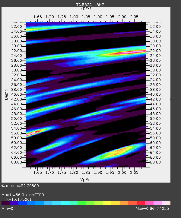
| Estimated Moho Depth: |
56.0 km |
| Estimated Crust Vp/Vs: |
1.62 |
| Assumed Crust Vp: |
6.498 km/s |
| Estimated Crust Vs: |
4.017 km/s |
| Estimated Crust Poisson's Ratio: |
0.19 |
|
| Radial Match: |
82.29589 % |
| Radial Bump: |
400 |
| Transverse Match: |
75.123566 % |
| Transverse Bump: |
365 |
| SOD ConfigId: |
2622 |
| Insert Time: |
2010-03-06 00:09:04.286 +0000 |
| GWidth: |
2.5 |
| Max Bumps: |
400 |
| Tol: |
0.001 |
|
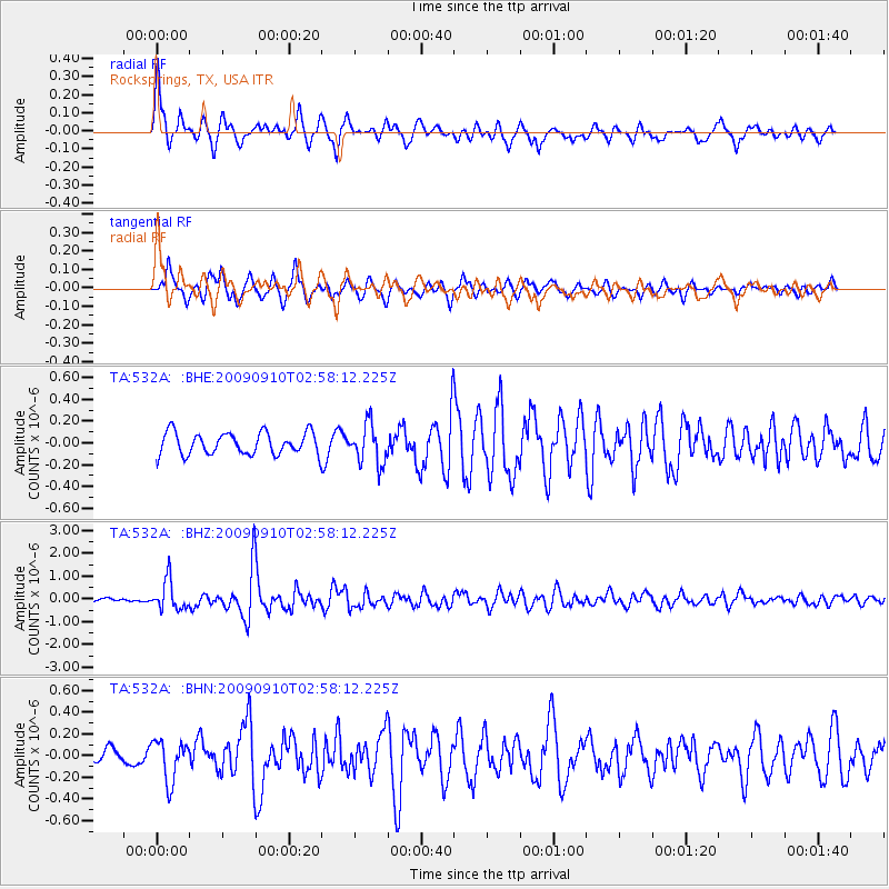
Signal To Noise
| Channel | StoN | STA | LTA |
| TA:532A: :BHZ:20090910T02:58:12.225Z | 5.73526 | 6.423519E-7 | 1.12000485E-7 |
| TA:532A: :BHN:20090910T02:58:12.225Z | 1.9572759 | 1.8701623E-7 | 9.554925E-8 |
| TA:532A: :BHE:20090910T02:58:12.225Z | 1.8201684 | 1.8282437E-7 | 1.0044366E-7 |
| Arrivals |
| Ps | 5.5 SECOND |
| PpPs | 22 SECOND |
| PsPs/PpSs | 27 SECOND |


