You are here: Home > Network List > IU - Global Seismograph Network (GSN - IRIS/USGS) Stations List
> Station AFI Afiamalu, Samoa > Earthquake Result Viewer
AFI Afiamalu, Samoa - Earthquake Result Viewer

| Earthquake location: |
Banda Sea |
| Earthquake latitude/longitude: |
-6.1/130.4 |
| Earthquake time(UTC): |
2009/10/24 (297) 14:40:43 GMT |
| Earthquake Depth: |
130 km |
| Earthquake Magnitude: |
6.7 MB, 6.9 MW, 6.9 MW |
| Earthquake Catalog/Contributor: |
WHDF/NEIC |
|
| Network: |
IU Global Seismograph Network (GSN - IRIS/USGS) |
| Station: |
AFI Afiamalu, Samoa |
| Lat/Lon: |
13.91 S/171.78 W |
| Elevation: |
706 m |
|
| Distance: |
57.4 deg |
| Az: |
102.528 deg |
| Baz: |
271.591 deg |
| Ray Param: |
0.063144416 |
| Estimated Moho Depth: |
13.75 km |
| Estimated Crust Vp/Vs: |
1.73 |
| Assumed Crust Vp: |
4.24 km/s |
| Estimated Crust Vs: |
2.454 km/s |
| Estimated Crust Poisson's Ratio: |
0.25 |
|
| Radial Match: |
88.20217 % |
| Radial Bump: |
400 |
| Transverse Match: |
70.95551 % |
| Transverse Bump: |
400 |
| SOD ConfigId: |
1 |
| Insert Time: |
2010-02-19 00:55:46.490 +0000 |
| GWidth: |
2.5 |
| Max Bumps: |
400 |
| Tol: |
0.001 |
|
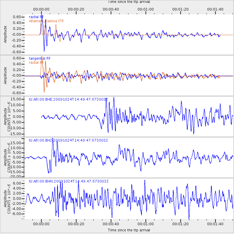
Signal To Noise
| Channel | StoN | STA | LTA |
| IU:AFI:00:BHZ:20091024T14:49:47.673003Z | 10.062847 | 6.410786E-6 | 6.370748E-7 |
| IU:AFI:00:BHN:20091024T14:49:47.673003Z | 0.8179952 | 8.9799295E-7 | 1.0977974E-6 |
| IU:AFI:00:BHE:20091024T14:49:47.673003Z | 3.1997573 | 3.831723E-6 | 1.1975043E-6 |
| Arrivals |
| Ps | 2.4 SECOND |
| PpPs | 8.7 SECOND |
| PsPs/PpSs | 11 SECOND |


