You are here: Home > Network List > TA - USArray Transportable Network (new EarthScope stations) Stations List
> Station 532A Rocksprings, TX, USA > Earthquake Result Viewer
532A Rocksprings, TX, USA - Earthquake Result Viewer

| Earthquake location: |
Samoa Islands Region |
| Earthquake latitude/longitude: |
-14.9/-174.8 |
| Earthquake time(UTC): |
2009/10/14 (287) 18:00:21 GMT |
| Earthquake Depth: |
10 km |
| Earthquake Magnitude: |
5.7 MB, 6.0 MS, 6.3 MW, 6.2 MW |
| Earthquake Catalog/Contributor: |
WHDF/NEIC |
|
| Network: |
TA USArray Transportable Network (new EarthScope stations) |
| Station: |
532A Rocksprings, TX, USA |
| Lat/Lon: |
30.13 N/99.90 W |
| Elevation: |
703 m |
|
| Distance: |
84.8 deg |
| Az: |
57.135 deg |
| Baz: |
249.6 deg |
| Ray Param: |
0.045206636 |
| Estimated Moho Depth: |
45.0 km |
| Estimated Crust Vp/Vs: |
1.97 |
| Assumed Crust Vp: |
6.498 km/s |
| Estimated Crust Vs: |
3.298 km/s |
| Estimated Crust Poisson's Ratio: |
0.33 |
|
| Radial Match: |
87.026085 % |
| Radial Bump: |
400 |
| Transverse Match: |
70.92274 % |
| Transverse Bump: |
400 |
| SOD ConfigId: |
2622 |
| Insert Time: |
2010-03-06 00:09:19.018 +0000 |
| GWidth: |
2.5 |
| Max Bumps: |
400 |
| Tol: |
0.001 |
|
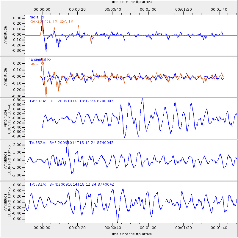
Signal To Noise
| Channel | StoN | STA | LTA |
| TA:532A: :BHZ:20091014T18:12:24.874004Z | 2.2283502 | 3.5114076E-7 | 1.575788E-7 |
| TA:532A: :BHN:20091014T18:12:24.874004Z | 0.761466 | 1.2918399E-7 | 1.6965167E-7 |
| TA:532A: :BHE:20091014T18:12:24.874004Z | 0.9038103 | 1.1421218E-7 | 1.2636741E-7 |
| Arrivals |
| Ps | 6.9 SECOND |
| PpPs | 20 SECOND |
| PsPs/PpSs | 27 SECOND |


