You are here: Home > Network List > TA - USArray Transportable Network (new EarthScope stations) Stations List
> Station 532A Rocksprings, TX, USA > Earthquake Result Viewer
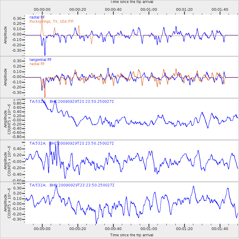
532A Rocksprings, TX, USA - Earthquake Result Viewer
*The percent match for this event was below the threshold and hence no stack was calculated.
| Earthquake location: |
Tonga Islands |
| Earthquake latitude/longitude: |
-15.6/-173.4 |
| Earthquake time(UTC): |
2009/09/29 (272) 23:11:51 GMT |
| Earthquake Depth: |
10 km |
| Earthquake Magnitude: |
5.5 MB |
| Earthquake Catalog/Contributor: |
WHDF/NEIC |
|
| Network: |
TA USArray Transportable Network (new EarthScope stations) |
| Station: |
532A Rocksprings, TX, USA |
| Lat/Lon: |
30.13 N/99.90 W |
| Elevation: |
703 m |
|
| Distance: |
84.0 deg |
| Az: |
56.624 deg |
| Baz: |
248.249 deg |
| Ray Param: |
$rayparam |
*The percent match for this event was below the threshold and hence was not used in the summary stack. |
|
| Radial Match: |
58.84354 % |
| Radial Bump: |
313 |
| Transverse Match: |
64.0976 % |
| Transverse Bump: |
400 |
| SOD ConfigId: |
2622 |
| Insert Time: |
2010-03-06 00:09:51.645 +0000 |
| GWidth: |
2.5 |
| Max Bumps: |
400 |
| Tol: |
0.001 |
|
Signal To Noise
| Channel | StoN | STA | LTA |
| TA:532A: :BHZ:20090929T23:23:50.250027Z | 0.8953734 | 3.5596847E-7 | 3.975643E-7 |
| TA:532A: :BHN:20090929T23:23:50.250027Z | 0.509496 | 4.789769E-8 | 9.400994E-8 |
| TA:532A: :BHE:20090929T23:23:50.250027Z | 1.3442028 | 4.2893498E-7 | 3.190999E-7 |
| Arrivals |
| Ps | |
| PpPs | |
| PsPs/PpSs | |


