You are here: Home > Network List > TA - USArray Transportable Network (new EarthScope stations) Stations List
> Station 532A Rocksprings, TX, USA > Earthquake Result Viewer
532A Rocksprings, TX, USA - Earthquake Result Viewer
*The percent match for this event was below the threshold and hence no stack was calculated.
| Earthquake location: |
South Of Fiji Islands |
| Earthquake latitude/longitude: |
-22.0/-179.6 |
| Earthquake time(UTC): |
2009/06/07 (158) 12:46:30 GMT |
| Earthquake Depth: |
590 km |
| Earthquake Magnitude: |
5.5 MW, 5.1 MB |
| Earthquake Catalog/Contributor: |
WHDF/NEIC |
|
| Network: |
TA USArray Transportable Network (new EarthScope stations) |
| Station: |
532A Rocksprings, TX, USA |
| Lat/Lon: |
30.13 N/99.90 W |
| Elevation: |
703 m |
|
| Distance: |
92.4 deg |
| Az: |
58.551 deg |
| Baz: |
246.01 deg |
| Ray Param: |
$rayparam |
*The percent match for this event was below the threshold and hence was not used in the summary stack. |
|
| Radial Match: |
35.47683 % |
| Radial Bump: |
400 |
| Transverse Match: |
63.39403 % |
| Transverse Bump: |
400 |
| SOD ConfigId: |
2648 |
| Insert Time: |
2010-03-06 00:09:59.774 +0000 |
| GWidth: |
2.5 |
| Max Bumps: |
400 |
| Tol: |
0.001 |
|
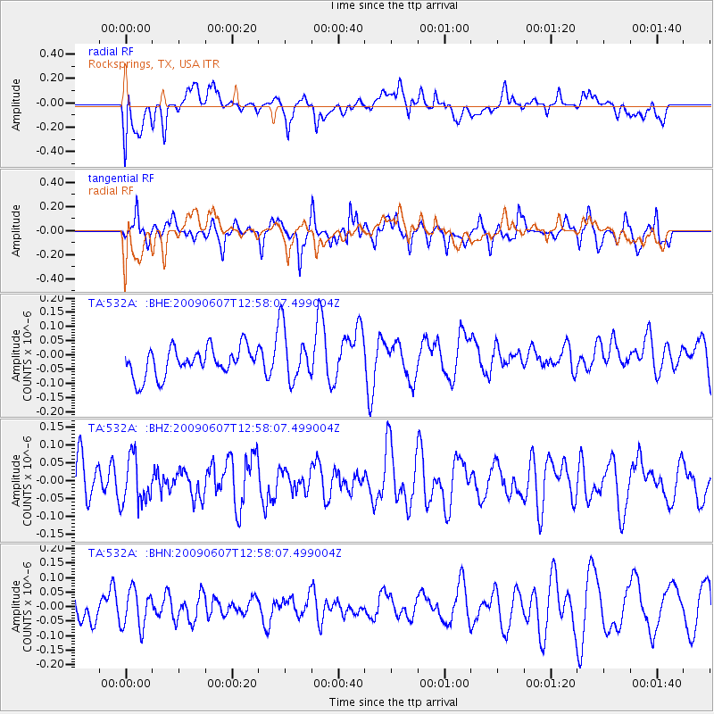
Signal To Noise
| Channel | StoN | STA | LTA |
| TA:532A: :BHZ:20090607T12:58:07.499004Z | 1.1528187 | 6.479539E-8 | 5.6206055E-8 |
| TA:532A: :BHN:20090607T12:58:07.499004Z | 1.111657 | 6.540118E-8 | 5.8832157E-8 |
| TA:532A: :BHE:20090607T12:58:07.499004Z | 1.8447404 | 9.262555E-8 | 5.0210616E-8 |
| Arrivals |
| Ps | |
| PpPs | |
| PsPs/PpSs | |


