You are here: Home > Network List > TA - USArray Transportable Network (new EarthScope stations) Stations List
> Station 532A Rocksprings, TX, USA > Earthquake Result Viewer
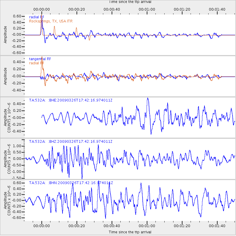
532A Rocksprings, TX, USA - Earthquake Result Viewer
*The percent match for this event was below the threshold and hence no stack was calculated.
| Earthquake location: |
Near Coast Of Northern Peru |
| Earthquake latitude/longitude: |
-5.7/-81.3 |
| Earthquake time(UTC): |
2009/03/26 (085) 17:35:14 GMT |
| Earthquake Depth: |
10 km |
| Earthquake Magnitude: |
5.6 MB, 5.5 MS, 5.8 MW, 5.7 MW |
| Earthquake Catalog/Contributor: |
WHDF/NEIC |
|
| Network: |
TA USArray Transportable Network (new EarthScope stations) |
| Station: |
532A Rocksprings, TX, USA |
| Lat/Lon: |
30.13 N/99.90 W |
| Elevation: |
703 m |
|
| Distance: |
39.8 deg |
| Az: |
334.497 deg |
| Baz: |
150.361 deg |
| Ray Param: |
$rayparam |
*The percent match for this event was below the threshold and hence was not used in the summary stack. |
|
| Radial Match: |
72.5279 % |
| Radial Bump: |
357 |
| Transverse Match: |
65.745056 % |
| Transverse Bump: |
400 |
| SOD ConfigId: |
2658 |
| Insert Time: |
2010-03-06 00:10:10.219 +0000 |
| GWidth: |
2.5 |
| Max Bumps: |
400 |
| Tol: |
0.001 |
|
Signal To Noise
| Channel | StoN | STA | LTA |
| TA:532A: :BHZ:20090326T17:42:16.974011Z | 2.6043472 | 2.8009296E-7 | 1.07548246E-7 |
| TA:532A: :BHN:20090326T17:42:16.974011Z | 1.0714979 | 1.5538548E-7 | 1.4501705E-7 |
| TA:532A: :BHE:20090326T17:42:16.974011Z | 0.6832203 | 6.242633E-8 | 9.137072E-8 |
| Arrivals |
| Ps | |
| PpPs | |
| PsPs/PpSs | |


