You are here: Home > Network List > TA - USArray Transportable Network (new EarthScope stations) Stations List
> Station 532A Rocksprings, TX, USA > Earthquake Result Viewer
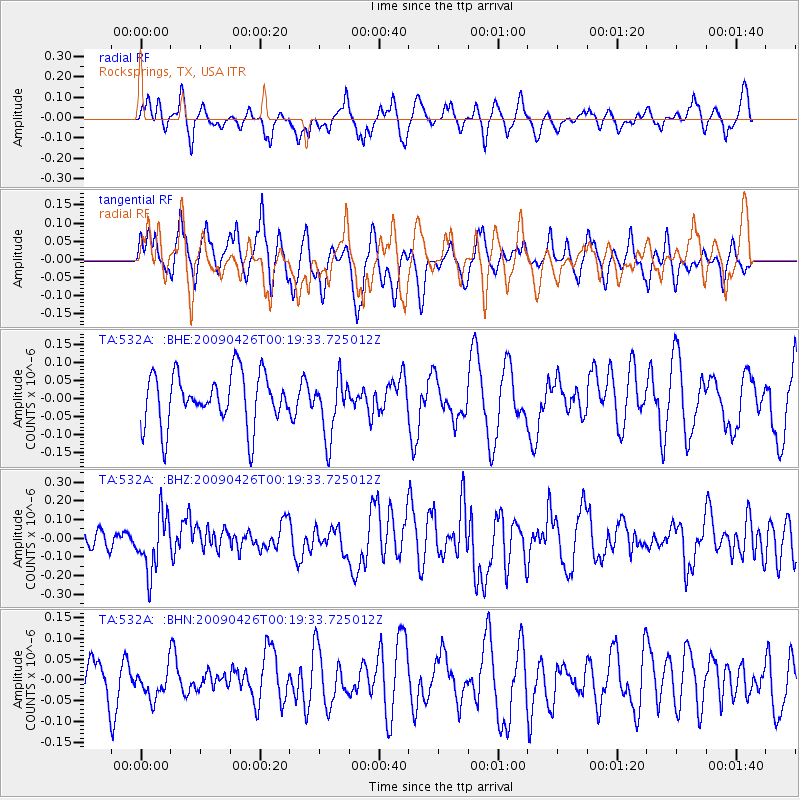
532A Rocksprings, TX, USA - Earthquake Result Viewer
*The percent match for this event was below the threshold and hence no stack was calculated.
| Earthquake location: |
Kermadec Islands, New Zealand |
| Earthquake latitude/longitude: |
-30.3/-178.6 |
| Earthquake time(UTC): |
2009/04/26 (116) 00:06:53 GMT |
| Earthquake Depth: |
132 km |
| Earthquake Magnitude: |
5.5 MB, 6.1 MW, 6.1 MW |
| Earthquake Catalog/Contributor: |
WHDF/NEIC |
|
| Network: |
TA USArray Transportable Network (new EarthScope stations) |
| Station: |
532A Rocksprings, TX, USA |
| Lat/Lon: |
30.13 N/99.90 W |
| Elevation: |
703 m |
|
| Distance: |
95.9 deg |
| Az: |
58.66 deg |
| Baz: |
238.498 deg |
| Ray Param: |
$rayparam |
*The percent match for this event was below the threshold and hence was not used in the summary stack. |
|
| Radial Match: |
45.9304 % |
| Radial Bump: |
324 |
| Transverse Match: |
45.57583 % |
| Transverse Bump: |
333 |
| SOD ConfigId: |
2658 |
| Insert Time: |
2010-03-06 00:10:12.142 +0000 |
| GWidth: |
2.5 |
| Max Bumps: |
400 |
| Tol: |
0.001 |
|
Signal To Noise
| Channel | StoN | STA | LTA |
| TA:532A: :BHZ:20090426T00:19:33.725012Z | 2.7347505 | 1.5308316E-7 | 5.5977015E-8 |
| TA:532A: :BHN:20090426T00:19:33.725012Z | 0.46739268 | 3.5758365E-8 | 7.650605E-8 |
| TA:532A: :BHE:20090426T00:19:33.725012Z | 1.1497624 | 8.326004E-8 | 7.2415E-8 |
| Arrivals |
| Ps | |
| PpPs | |
| PsPs/PpSs | |


