You are here: Home > Network List > TA - USArray Transportable Network (new EarthScope stations) Stations List
> Station 532A Rocksprings, TX, USA > Earthquake Result Viewer
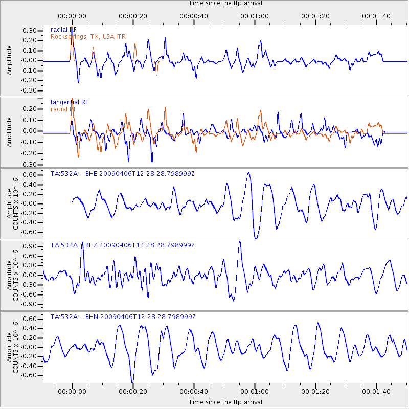
532A Rocksprings, TX, USA - Earthquake Result Viewer
*The percent match for this event was below the threshold and hence no stack was calculated.
| Earthquake location: |
Tonga Islands Region |
| Earthquake latitude/longitude: |
-22.4/-174.9 |
| Earthquake time(UTC): |
2009/04/06 (096) 12:16:08 GMT |
| Earthquake Depth: |
35 km |
| Earthquake Magnitude: |
5.5 MS, 5.4 MB |
| Earthquake Catalog/Contributor: |
WHDF/NEIC |
|
| Network: |
TA USArray Transportable Network (new EarthScope stations) |
| Station: |
532A Rocksprings, TX, USA |
| Lat/Lon: |
30.13 N/99.90 W |
| Elevation: |
703 m |
|
| Distance: |
89.0 deg |
| Az: |
56.836 deg |
| Baz: |
243.418 deg |
| Ray Param: |
$rayparam |
*The percent match for this event was below the threshold and hence was not used in the summary stack. |
|
| Radial Match: |
56.811157 % |
| Radial Bump: |
373 |
| Transverse Match: |
47.673332 % |
| Transverse Bump: |
308 |
| SOD ConfigId: |
2658 |
| Insert Time: |
2010-03-06 00:10:14.446 +0000 |
| GWidth: |
2.5 |
| Max Bumps: |
400 |
| Tol: |
0.001 |
|
Signal To Noise
| Channel | StoN | STA | LTA |
| TA:532A: :BHZ:20090406T12:28:28.798999Z | 3.5000806 | 4.5508918E-7 | 1.3002249E-7 |
| TA:532A: :BHN:20090406T12:28:28.798999Z | 0.19341445 | 3.999992E-8 | 2.0680937E-7 |
| TA:532A: :BHE:20090406T12:28:28.798999Z | 1.0603455 | 1.4543015E-7 | 1.3715355E-7 |
| Arrivals |
| Ps | |
| PpPs | |
| PsPs/PpSs | |


