You are here: Home > Network List > TA - USArray Transportable Network (new EarthScope stations) Stations List
> Station 330A Mertzon, TX, USA > Earthquake Result Viewer
330A Mertzon, TX, USA - Earthquake Result Viewer
| Earthquake location: |
Samoa Islands Region |
| Earthquake latitude/longitude: |
-15.2/-172.6 |
| Earthquake time(UTC): |
2009/08/30 (242) 14:51:32 GMT |
| Earthquake Depth: |
11 km |
| Earthquake Magnitude: |
6.4 MB, 6.3 MS, 6.6 MW, 6.6 MW |
| Earthquake Catalog/Contributor: |
WHDF/NEIC |
|
| Network: |
TA USArray Transportable Network (new EarthScope stations) |
| Station: |
330A Mertzon, TX, USA |
| Lat/Lon: |
31.41 N/101.18 W |
| Elevation: |
742 m |
|
| Distance: |
82.6 deg |
| Az: |
54.794 deg |
| Baz: |
247.295 deg |
| Ray Param: |
0.04674201 |
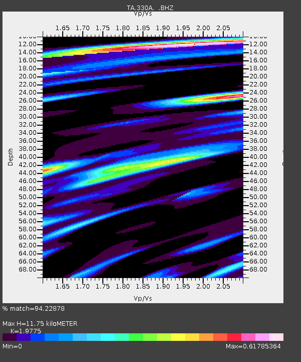
| Estimated Moho Depth: |
11.75 km |
| Estimated Crust Vp/Vs: |
1.98 |
| Assumed Crust Vp: |
6.38 km/s |
| Estimated Crust Vs: |
3.227 km/s |
| Estimated Crust Poisson's Ratio: |
0.33 |
|
| Radial Match: |
94.22878 % |
| Radial Bump: |
400 |
| Transverse Match: |
87.85469 % |
| Transverse Bump: |
400 |
| SOD ConfigId: |
2622 |
| Insert Time: |
2010-03-06 00:10:30.844 +0000 |
| GWidth: |
2.5 |
| Max Bumps: |
400 |
| Tol: |
0.001 |
|

Signal To Noise
| Channel | StoN | STA | LTA |
| TA:330A: :BHZ:20090830T15:03:24.725022Z | 25.62468 | 3.3997328E-6 | 1.3267416E-7 |
| TA:330A: :BHN:20090830T15:03:24.725022Z | 4.0542846 | 3.7933853E-7 | 9.356486E-8 |
| TA:330A: :BHE:20090830T15:03:24.725022Z | 7.4696836 | 8.9658016E-7 | 1.200292E-7 |
| Arrivals |
| Ps | 1.8 SECOND |
| PpPs | 5.4 SECOND |
| PsPs/PpSs | 7.2 SECOND |


