You are here: Home > Network List > TA - USArray Transportable Network (new EarthScope stations) Stations List
> Station BGNE Belgrade, NE, USA > Earthquake Result Viewer
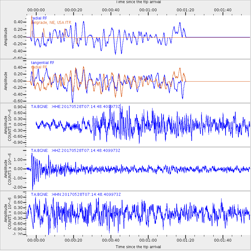
BGNE Belgrade, NE, USA - Earthquake Result Viewer
*The percent match for this event was below the threshold and hence no stack was calculated.
| Earthquake location: |
Andreanof Islands, Aleutian Is. |
| Earthquake latitude/longitude: |
51.6/-175.3 |
| Earthquake time(UTC): |
2017/05/28 (148) 07:06:14 GMT |
| Earthquake Depth: |
8.0 km |
| Earthquake Magnitude: |
5.6 Ml |
| Earthquake Catalog/Contributor: |
NEIC PDE/at |
|
| Network: |
TA USArray Transportable Network (new EarthScope stations) |
| Station: |
BGNE Belgrade, NE, USA |
| Lat/Lon: |
41.41 N/98.15 W |
| Elevation: |
573 m |
|
| Distance: |
51.7 deg |
| Az: |
69.073 deg |
| Baz: |
309.206 deg |
| Ray Param: |
$rayparam |
*The percent match for this event was below the threshold and hence was not used in the summary stack. |
|
| Radial Match: |
40.17413 % |
| Radial Bump: |
400 |
| Transverse Match: |
64.67074 % |
| Transverse Bump: |
400 |
| SOD ConfigId: |
13570011 |
| Insert Time: |
2019-04-28 02:30:14.213 +0000 |
| GWidth: |
2.5 |
| Max Bumps: |
400 |
| Tol: |
0.001 |
|
Signal To Noise
| Channel | StoN | STA | LTA |
| TA:BGNE: :HHZ:20170528T07:14:48.409973Z | 6.243003 | 6.5935774E-7 | 1.05615484E-7 |
| TA:BGNE: :HHN:20170528T07:14:48.409973Z | 2.0527654 | 3.9223306E-7 | 1.9107546E-7 |
| TA:BGNE: :HHE:20170528T07:14:48.409973Z | 2.0521252 | 2.9783808E-7 | 1.4513641E-7 |
| Arrivals |
| Ps | |
| PpPs | |
| PsPs/PpSs | |


