You are here: Home > Network List > TA - USArray Transportable Network (new EarthScope stations) Stations List
> Station L44A Lake County Forest Preserve, Grayslake, IL, USA > Earthquake Result Viewer
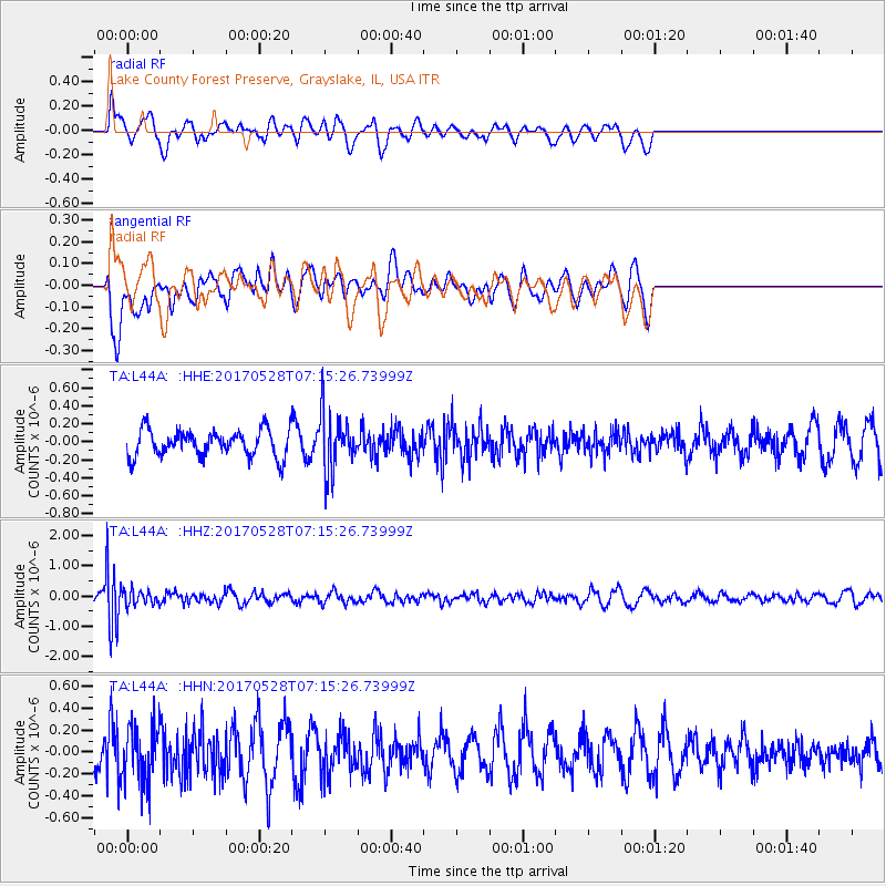
L44A Lake County Forest Preserve, Grayslake, IL, USA - Earthquake Result Viewer
*The percent match for this event was below the threshold and hence no stack was calculated.
| Earthquake location: |
Andreanof Islands, Aleutian Is. |
| Earthquake latitude/longitude: |
51.6/-175.3 |
| Earthquake time(UTC): |
2017/05/28 (148) 07:06:14 GMT |
| Earthquake Depth: |
8.0 km |
| Earthquake Magnitude: |
5.6 Ml |
| Earthquake Catalog/Contributor: |
NEIC PDE/at |
|
| Network: |
TA USArray Transportable Network (new EarthScope stations) |
| Station: |
L44A Lake County Forest Preserve, Grayslake, IL, USA |
| Lat/Lon: |
42.18 N/87.91 W |
| Elevation: |
202 m |
|
| Distance: |
57.1 deg |
| Az: |
62.232 deg |
| Baz: |
312.024 deg |
| Ray Param: |
$rayparam |
*The percent match for this event was below the threshold and hence was not used in the summary stack. |
|
| Radial Match: |
58.91429 % |
| Radial Bump: |
400 |
| Transverse Match: |
67.43492 % |
| Transverse Bump: |
400 |
| SOD ConfigId: |
13570011 |
| Insert Time: |
2019-04-28 02:30:18.250 +0000 |
| GWidth: |
2.5 |
| Max Bumps: |
400 |
| Tol: |
0.001 |
|
Signal To Noise
| Channel | StoN | STA | LTA |
| TA:L44A: :HHZ:20170528T07:15:26.73999Z | 2.1375556 | 2.4599038E-7 | 1.1508022E-7 |
| TA:L44A: :HHN:20170528T07:15:26.73999Z | 2.2438462 | 2.636346E-7 | 1.1749227E-7 |
| TA:L44A: :HHE:20170528T07:15:26.73999Z | 0.983803 | 1.4616586E-7 | 1.4857228E-7 |
| Arrivals |
| Ps | |
| PpPs | |
| PsPs/PpSs | |


