You are here: Home > Network List > US - United States National Seismic Network Stations List
> Station DUG Dugway, Tooele County, Utah, USA > Earthquake Result Viewer
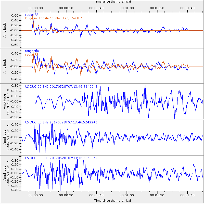
DUG Dugway, Tooele County, Utah, USA - Earthquake Result Viewer
*The percent match for this event was below the threshold and hence no stack was calculated.
| Earthquake location: |
Andreanof Islands, Aleutian Is. |
| Earthquake latitude/longitude: |
51.6/-175.3 |
| Earthquake time(UTC): |
2017/05/28 (148) 07:06:14 GMT |
| Earthquake Depth: |
8.0 km |
| Earthquake Magnitude: |
5.6 Ml |
| Earthquake Catalog/Contributor: |
NEIC PDE/at |
|
| Network: |
US United States National Seismic Network |
| Station: |
DUG Dugway, Tooele County, Utah, USA |
| Lat/Lon: |
40.19 N/112.81 W |
| Elevation: |
1477 m |
|
| Distance: |
43.7 deg |
| Az: |
79.603 deg |
| Baz: |
306.745 deg |
| Ray Param: |
$rayparam |
*The percent match for this event was below the threshold and hence was not used in the summary stack. |
|
| Radial Match: |
80.417175 % |
| Radial Bump: |
400 |
| Transverse Match: |
62.10577 % |
| Transverse Bump: |
400 |
| SOD ConfigId: |
13570011 |
| Insert Time: |
2019-04-28 02:31:06.079 +0000 |
| GWidth: |
2.5 |
| Max Bumps: |
400 |
| Tol: |
0.001 |
|
Signal To Noise
| Channel | StoN | STA | LTA |
| US:DUG:00:BHZ:20170528T07:13:46.524994Z | 4.209745 | 2.3827552E-7 | 5.6600943E-8 |
| US:DUG:00:BH1:20170528T07:13:46.524994Z | 2.4796824 | 1.4623149E-7 | 5.8971857E-8 |
| US:DUG:00:BH2:20170528T07:13:46.524994Z | 1.4324836 | 1.0244913E-7 | 7.1518535E-8 |
| Arrivals |
| Ps | |
| PpPs | |
| PsPs/PpSs | |


