You are here: Home > Network List > AK - Alaska Regional Network Stations List
> Station TNA Tin City Broadband > Earthquake Result Viewer
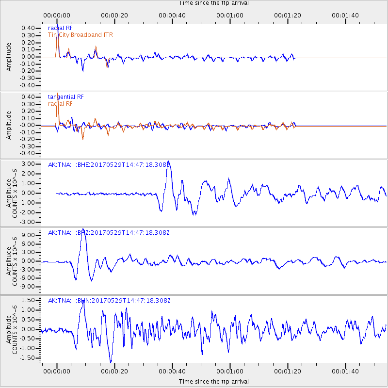
TNA Tin City Broadband - Earthquake Result Viewer

| Earthquake location: |
Sulawesi, Indonesia |
| Earthquake latitude/longitude: |
-1.3/120.5 |
| Earthquake time(UTC): |
2017/05/29 (149) 14:35:20 GMT |
| Earthquake Depth: |
9.4 km |
| Earthquake Magnitude: |
6.6 Mww |
| Earthquake Catalog/Contributor: |
NEIC PDE/us |
|
| Network: |
AK Alaska Regional Network |
| Station: |
TNA Tin City Broadband |
| Lat/Lon: |
65.56 N/167.92 W |
| Elevation: |
74 m |
|
| Distance: |
83.6 deg |
| Az: |
23.405 deg |
| Baz: |
252.664 deg |
| Ray Param: |
0.04606982 |
| Estimated Moho Depth: |
29.75 km |
| Estimated Crust Vp/Vs: |
1.89 |
| Assumed Crust Vp: |
6.307 km/s |
| Estimated Crust Vs: |
3.341 km/s |
| Estimated Crust Poisson's Ratio: |
0.30 |
|
| Radial Match: |
92.320015 % |
| Radial Bump: |
327 |
| Transverse Match: |
76.86931 % |
| Transverse Bump: |
400 |
| SOD ConfigId: |
13570011 |
| Insert Time: |
2019-04-28 02:33:05.271 +0000 |
| GWidth: |
2.5 |
| Max Bumps: |
400 |
| Tol: |
0.001 |
|
Signal To Noise
| Channel | StoN | STA | LTA |
| AK:TNA: :BHZ:20170529T14:47:18.308Z | 2.4281924 | 1.7299145E-7 | 7.1242894E-8 |
| AK:TNA: :BHN:20170529T14:47:18.308Z | 0.78553385 | 7.1916915E-8 | 9.155165E-8 |
| AK:TNA: :BHE:20170529T14:47:18.308Z | 1.4248298 | 8.081703E-8 | 5.672048E-8 |
| Arrivals |
| Ps | 4.3 SECOND |
| PpPs | 13 SECOND |
| PsPs/PpSs | 18 SECOND |


