You are here: Home > Network List > AV - Alaska Volcano Observatory Stations List
> Station MNAT Nateekin Bay, Makushin Volcano, Alaska > Earthquake Result Viewer
MNAT Nateekin Bay, Makushin Volcano, Alaska - Earthquake Result Viewer
| Earthquake location: |
Sulawesi, Indonesia |
| Earthquake latitude/longitude: |
-1.3/120.5 |
| Earthquake time(UTC): |
2017/05/29 (149) 14:35:20 GMT |
| Earthquake Depth: |
9.4 km |
| Earthquake Magnitude: |
6.6 Mww |
| Earthquake Catalog/Contributor: |
NEIC PDE/us |
|
| Network: |
AV Alaska Volcano Observatory |
| Station: |
MNAT Nateekin Bay, Makushin Volcano, Alaska |
| Lat/Lon: |
53.88 N/166.69 W |
| Elevation: |
390 m |
|
| Distance: |
81.0 deg |
| Az: |
34.943 deg |
| Baz: |
255.292 deg |
| Ray Param: |
0.047918364 |
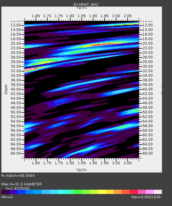
| Estimated Moho Depth: |
31.0 km |
| Estimated Crust Vp/Vs: |
1.62 |
| Assumed Crust Vp: |
3.943 km/s |
| Estimated Crust Vs: |
2.43 km/s |
| Estimated Crust Poisson's Ratio: |
0.19 |
|
| Radial Match: |
86.5484 % |
| Radial Bump: |
400 |
| Transverse Match: |
74.2646 % |
| Transverse Bump: |
400 |
| SOD ConfigId: |
13570011 |
| Insert Time: |
2019-04-28 02:33:36.040 +0000 |
| GWidth: |
2.5 |
| Max Bumps: |
400 |
| Tol: |
0.001 |
|
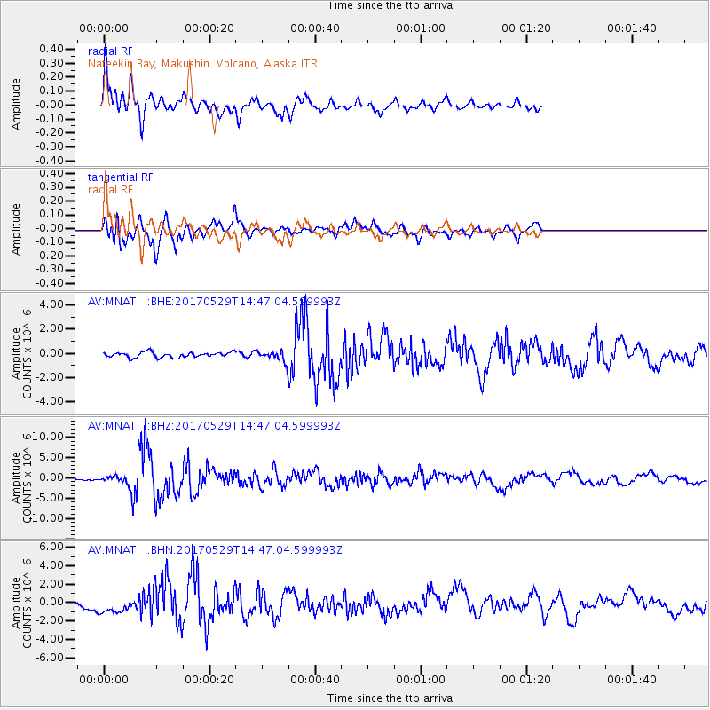
Signal To Noise
| Channel | StoN | STA | LTA |
| AV:MNAT: :BHZ:20170529T14:47:04.599993Z | 4.313909 | 7.5360634E-7 | 1.7469222E-7 |
| AV:MNAT: :BHN:20170529T14:47:04.599993Z | 4.0379605 | 8.94357E-7 | 2.2148731E-7 |
| AV:MNAT: :BHE:20170529T14:47:04.599993Z | 1.4915724 | 3.100861E-7 | 2.078921E-7 |
| Arrivals |
| Ps | 4.9 SECOND |
| PpPs | 20 SECOND |
| PsPs/PpSs | 25 SECOND |


