You are here: Home > Network List > AV - Alaska Volcano Observatory Stations List
> Station SPCR Ckakachatna River, Mount Spurr, Alaska > Earthquake Result Viewer
SPCR Ckakachatna River, Mount Spurr, Alaska - Earthquake Result Viewer
| Earthquake location: |
Sulawesi, Indonesia |
| Earthquake latitude/longitude: |
-1.3/120.5 |
| Earthquake time(UTC): |
2017/05/29 (149) 14:35:20 GMT |
| Earthquake Depth: |
9.4 km |
| Earthquake Magnitude: |
6.6 Mww |
| Earthquake Catalog/Contributor: |
NEIC PDE/us |
|
| Network: |
AV Alaska Volcano Observatory |
| Station: |
SPCR Ckakachatna River, Mount Spurr, Alaska |
| Lat/Lon: |
61.20 N/152.21 W |
| Elevation: |
984 m |
|
| Distance: |
89.8 deg |
| Az: |
28.928 deg |
| Baz: |
267.041 deg |
| Ray Param: |
0.04171907 |
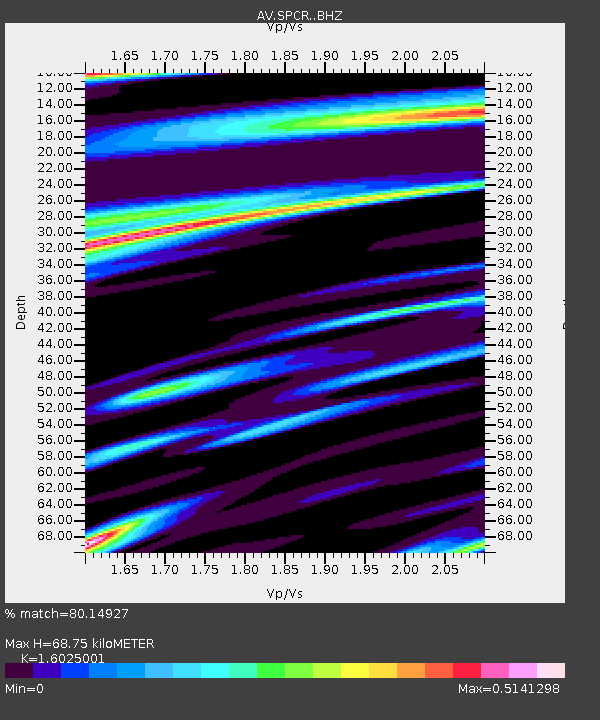
| Estimated Moho Depth: |
68.75 km |
| Estimated Crust Vp/Vs: |
1.60 |
| Assumed Crust Vp: |
6.566 km/s |
| Estimated Crust Vs: |
4.097 km/s |
| Estimated Crust Poisson's Ratio: |
0.18 |
|
| Radial Match: |
80.14927 % |
| Radial Bump: |
400 |
| Transverse Match: |
67.279945 % |
| Transverse Bump: |
400 |
| SOD ConfigId: |
13570011 |
| Insert Time: |
2019-04-28 02:33:42.435 +0000 |
| GWidth: |
2.5 |
| Max Bumps: |
400 |
| Tol: |
0.001 |
|

Signal To Noise
| Channel | StoN | STA | LTA |
| AV:SPCR: :BHZ:20170529T14:47:48.459978Z | 5.1039176 | 6.82201E-7 | 1.3366223E-7 |
| AV:SPCR: :BHN:20170529T14:47:48.459978Z | 0.7596075 | 1.637771E-7 | 2.1560754E-7 |
| AV:SPCR: :BHE:20170529T14:47:48.459978Z | 1.131638 | 1.1184794E-7 | 9.883721E-8 |
| Arrivals |
| Ps | 6.5 SECOND |
| PpPs | 27 SECOND |
| PsPs/PpSs | 33 SECOND |


