You are here: Home > Network List > KO - Kandilli Observatory Digital Broadband Seismic Network Stations List
> Station ELL Elmali-Antalya-Turkey > Earthquake Result Viewer
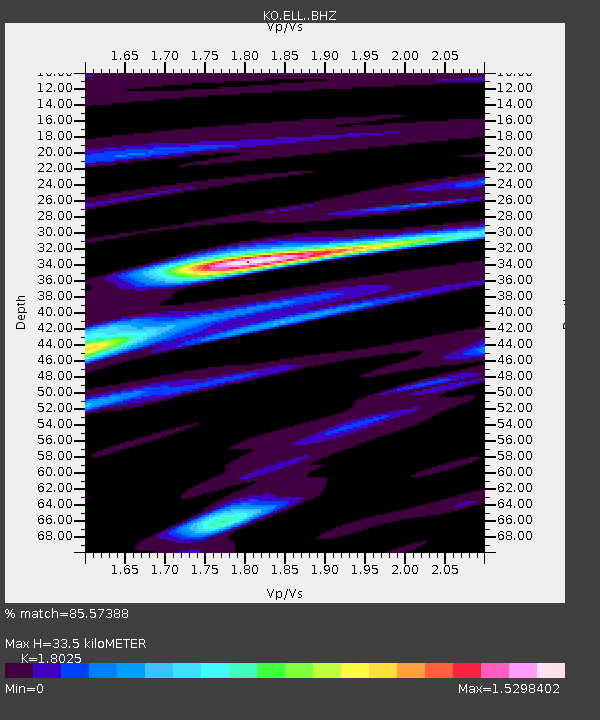
ELL Elmali-Antalya-Turkey - Earthquake Result Viewer
| Earthquake location: |
Sulawesi, Indonesia |
| Earthquake latitude/longitude: |
-1.3/120.5 |
| Earthquake time(UTC): |
2017/05/29 (149) 14:35:20 GMT |
| Earthquake Depth: |
9.4 km |
| Earthquake Magnitude: |
6.6 Mww |
| Earthquake Catalog/Contributor: |
NEIC PDE/us |
|
| Network: |
KO Kandilli Observatory Digital Broadband Seismic Network |
| Station: |
ELL Elmali-Antalya-Turkey |
| Lat/Lon: |
36.75 N/29.91 E |
| Elevation: |
1230 m |
|
| Distance: |
91.2 deg |
| Az: |
306.551 deg |
| Baz: |
90.67 deg |
| Ray Param: |
0.041618723 |
| Estimated Moho Depth: |
33.5 km |
| Estimated Crust Vp/Vs: |
1.80 |
| Assumed Crust Vp: |
6.12 km/s |
| Estimated Crust Vs: |
3.395 km/s |
| Estimated Crust Poisson's Ratio: |
0.28 |
|
| Radial Match: |
85.57388 % |
| Radial Bump: |
400 |
| Transverse Match: |
73.08903 % |
| Transverse Bump: |
400 |
| SOD ConfigId: |
13570011 |
| Insert Time: |
2019-04-28 02:34:39.011 +0000 |
| GWidth: |
2.5 |
| Max Bumps: |
400 |
| Tol: |
0.001 |
|

Signal To Noise
| Channel | StoN | STA | LTA |
| KO:ELL: :BHZ:20170529T14:47:54.68001Z | 9.025105 | 1.6925251E-6 | 1.875352E-7 |
| KO:ELL: :BHN:20170529T14:47:54.68001Z | 0.7015099 | 3.673374E-7 | 5.236382E-7 |
| KO:ELL: :BHE:20170529T14:47:54.68001Z | 1.9629235 | 4.2250247E-7 | 2.1524141E-7 |
| Arrivals |
| Ps | 4.5 SECOND |
| PpPs | 15 SECOND |
| PsPs/PpSs | 20 SECOND |


