You are here: Home > Network List > KS - Korea National Seismograph Network- KMA Stations List
> Station CHJ2 Chungju, South Korea > Earthquake Result Viewer
CHJ2 Chungju, South Korea - Earthquake Result Viewer
| Earthquake location: |
Sulawesi, Indonesia |
| Earthquake latitude/longitude: |
-1.3/120.5 |
| Earthquake time(UTC): |
2017/05/29 (149) 14:35:20 GMT |
| Earthquake Depth: |
9.4 km |
| Earthquake Magnitude: |
6.6 Mww |
| Earthquake Catalog/Contributor: |
NEIC PDE/us |
|
| Network: |
KS Korea National Seismograph Network- KMA |
| Station: |
CHJ2 Chungju, South Korea |
| Lat/Lon: |
36.87 N/127.97 E |
| Elevation: |
217 m |
|
| Distance: |
38.6 deg |
| Az: |
9.659 deg |
| Baz: |
192.074 deg |
| Ray Param: |
0.0754821 |
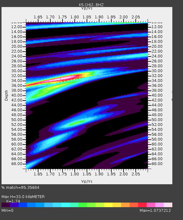
| Estimated Moho Depth: |
33.0 km |
| Estimated Crust Vp/Vs: |
1.74 |
| Assumed Crust Vp: |
6.459 km/s |
| Estimated Crust Vs: |
3.712 km/s |
| Estimated Crust Poisson's Ratio: |
0.25 |
|
| Radial Match: |
95.35684 % |
| Radial Bump: |
257 |
| Transverse Match: |
83.73249 % |
| Transverse Bump: |
400 |
| SOD ConfigId: |
13570011 |
| Insert Time: |
2019-04-28 02:34:53.197 +0000 |
| GWidth: |
2.5 |
| Max Bumps: |
400 |
| Tol: |
0.001 |
|

Signal To Noise
| Channel | StoN | STA | LTA |
| KS:CHJ2: :BHZ:20170529T14:42:13.568987Z | 3.8908005 | 2.0286026E-7 | 5.213844E-8 |
| KS:CHJ2: :BHN:20170529T14:42:13.568987Z | 2.134082 | 1.280842E-7 | 6.00184E-8 |
| KS:CHJ2: :BHE:20170529T14:42:13.568987Z | 0.5413988 | 4.6373867E-8 | 8.565564E-8 |
| Arrivals |
| Ps | 4.1 SECOND |
| PpPs | 13 SECOND |
| PsPs/PpSs | 17 SECOND |


