You are here: Home > Network List > TA - USArray Transportable Network (new EarthScope stations) Stations List
> Station E22K Anaktuvuk Pass, AK, USA > Earthquake Result Viewer
E22K Anaktuvuk Pass, AK, USA - Earthquake Result Viewer
| Earthquake location: |
Sulawesi, Indonesia |
| Earthquake latitude/longitude: |
-1.3/120.5 |
| Earthquake time(UTC): |
2017/05/29 (149) 14:35:20 GMT |
| Earthquake Depth: |
9.4 km |
| Earthquake Magnitude: |
6.6 Mww |
| Earthquake Catalog/Contributor: |
NEIC PDE/us |
|
| Network: |
TA USArray Transportable Network (new EarthScope stations) |
| Station: |
E22K Anaktuvuk Pass, AK, USA |
| Lat/Lon: |
68.13 N/151.81 W |
| Elevation: |
772 m |
|
| Distance: |
90.3 deg |
| Az: |
21.981 deg |
| Baz: |
267.405 deg |
| Ray Param: |
0.041682824 |
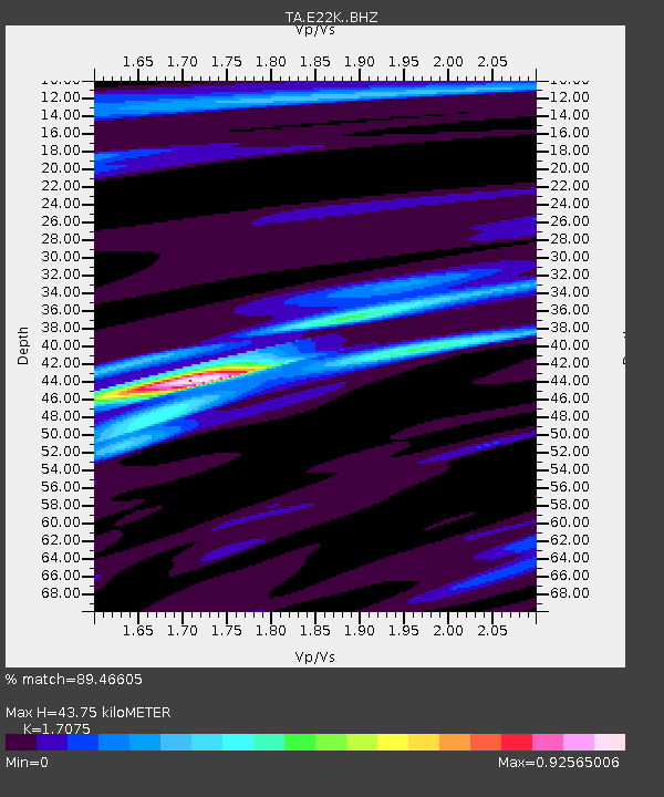
| Estimated Moho Depth: |
43.75 km |
| Estimated Crust Vp/Vs: |
1.71 |
| Assumed Crust Vp: |
6.221 km/s |
| Estimated Crust Vs: |
3.643 km/s |
| Estimated Crust Poisson's Ratio: |
0.24 |
|
| Radial Match: |
89.46605 % |
| Radial Bump: |
287 |
| Transverse Match: |
83.29281 % |
| Transverse Bump: |
400 |
| SOD ConfigId: |
13570011 |
| Insert Time: |
2019-04-28 02:35:31.782 +0000 |
| GWidth: |
2.5 |
| Max Bumps: |
400 |
| Tol: |
0.001 |
|

Signal To Noise
| Channel | StoN | STA | LTA |
| TA:E22K: :BHZ:20170529T14:47:50.800005Z | 3.5128605 | 1.3411062E-7 | 3.817704E-8 |
| TA:E22K: :BHN:20170529T14:47:50.800005Z | 0.7579409 | 4.156662E-8 | 5.4841507E-8 |
| TA:E22K: :BHE:20170529T14:47:50.800005Z | 0.9860008 | 3.2285083E-8 | 3.274347E-8 |
| Arrivals |
| Ps | 5.1 SECOND |
| PpPs | 19 SECOND |
| PsPs/PpSs | 24 SECOND |


