You are here: Home > Network List > TA - USArray Transportable Network (new EarthScope stations) Stations List
> Station F31M Tsiigehtchic, NWT, CAN > Earthquake Result Viewer
F31M Tsiigehtchic, NWT, CAN - Earthquake Result Viewer
| Earthquake location: |
Sulawesi, Indonesia |
| Earthquake latitude/longitude: |
-1.3/120.5 |
| Earthquake time(UTC): |
2017/05/29 (149) 14:35:20 GMT |
| Earthquake Depth: |
9.4 km |
| Earthquake Magnitude: |
6.6 Mww |
| Earthquake Catalog/Contributor: |
NEIC PDE/us |
|
| Network: |
TA USArray Transportable Network (new EarthScope stations) |
| Station: |
F31M Tsiigehtchic, NWT, CAN |
| Lat/Lon: |
67.44 N/133.74 W |
| Elevation: |
56 m |
|
| Distance: |
97.2 deg |
| Az: |
21.977 deg |
| Baz: |
284.14 deg |
| Ray Param: |
0.040290013 |
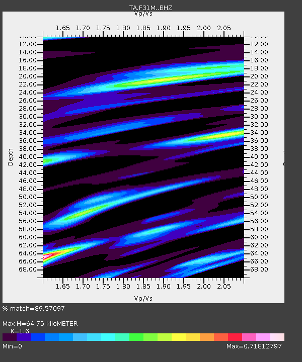
| Estimated Moho Depth: |
64.75 km |
| Estimated Crust Vp/Vs: |
1.60 |
| Assumed Crust Vp: |
6.171 km/s |
| Estimated Crust Vs: |
3.857 km/s |
| Estimated Crust Poisson's Ratio: |
0.18 |
|
| Radial Match: |
89.57097 % |
| Radial Bump: |
400 |
| Transverse Match: |
70.47916 % |
| Transverse Bump: |
400 |
| SOD ConfigId: |
13570011 |
| Insert Time: |
2019-04-28 02:35:40.474 +0000 |
| GWidth: |
2.5 |
| Max Bumps: |
400 |
| Tol: |
0.001 |
|
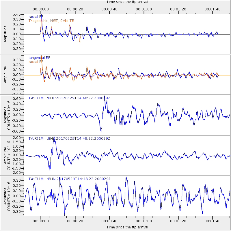
Signal To Noise
| Channel | StoN | STA | LTA |
| TA:F31M: :BHZ:20170529T14:48:22.200029Z | 8.064813 | 4.02262E-7 | 4.9878658E-8 |
| TA:F31M: :BHN:20170529T14:48:22.200029Z | 0.87391263 | 7.627072E-8 | 8.7275E-8 |
| TA:F31M: :BHE:20170529T14:48:22.200029Z | 2.446799 | 1.1761346E-7 | 4.8068298E-8 |
| Arrivals |
| Ps | 6.4 SECOND |
| PpPs | 27 SECOND |
| PsPs/PpSs | 33 SECOND |


