You are here: Home > Network List > TA - USArray Transportable Network (new EarthScope stations) Stations List
> Station H24K Noodor Dome, AK, USA > Earthquake Result Viewer
H24K Noodor Dome, AK, USA - Earthquake Result Viewer
| Earthquake location: |
Sulawesi, Indonesia |
| Earthquake latitude/longitude: |
-1.3/120.5 |
| Earthquake time(UTC): |
2017/05/29 (149) 14:35:20 GMT |
| Earthquake Depth: |
9.4 km |
| Earthquake Magnitude: |
6.6 Mww |
| Earthquake Catalog/Contributor: |
NEIC PDE/us |
|
| Network: |
TA USArray Transportable Network (new EarthScope stations) |
| Station: |
H24K Noodor Dome, AK, USA |
| Lat/Lon: |
65.84 N/147.88 W |
| Elevation: |
814 m |
|
| Distance: |
91.8 deg |
| Az: |
24.309 deg |
| Baz: |
270.981 deg |
| Ray Param: |
0.041551825 |
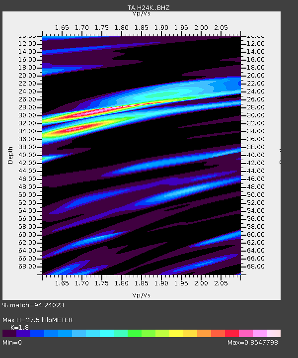
| Estimated Moho Depth: |
27.5 km |
| Estimated Crust Vp/Vs: |
1.80 |
| Assumed Crust Vp: |
6.566 km/s |
| Estimated Crust Vs: |
3.648 km/s |
| Estimated Crust Poisson's Ratio: |
0.28 |
|
| Radial Match: |
94.24023 % |
| Radial Bump: |
400 |
| Transverse Match: |
84.14593 % |
| Transverse Bump: |
400 |
| SOD ConfigId: |
13570011 |
| Insert Time: |
2019-04-28 02:35:45.582 +0000 |
| GWidth: |
2.5 |
| Max Bumps: |
400 |
| Tol: |
0.001 |
|
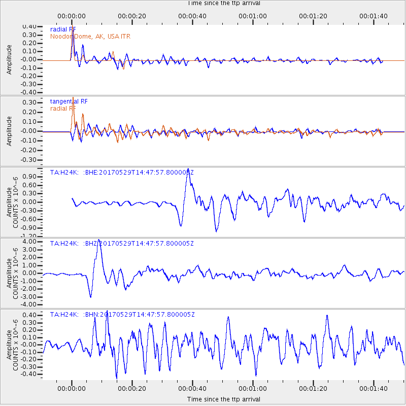
Signal To Noise
| Channel | StoN | STA | LTA |
| TA:H24K: :BHZ:20170529T14:47:57.800005Z | 1.7501379 | 1.3216932E-7 | 7.5519374E-8 |
| TA:H24K: :BHN:20170529T14:47:57.800005Z | 0.9614417 | 5.7210947E-8 | 5.9505375E-8 |
| TA:H24K: :BHE:20170529T14:47:57.800005Z | 1.4255306 | 6.8449616E-8 | 4.8016943E-8 |
| Arrivals |
| Ps | 3.4 SECOND |
| PpPs | 11 SECOND |
| PsPs/PpSs | 15 SECOND |


