You are here: Home > Network List > TA - USArray Transportable Network (new EarthScope stations) Stations List
> Station Z30A Sanderson Ranch, Post, TX, USA > Earthquake Result Viewer
Z30A Sanderson Ranch, Post, TX, USA - Earthquake Result Viewer
| Earthquake location: |
Tonga Islands |
| Earthquake latitude/longitude: |
-20.8/-174.3 |
| Earthquake time(UTC): |
2009/07/30 (211) 20:05:34 GMT |
| Earthquake Depth: |
10 km |
| Earthquake Magnitude: |
5.9 MB, 5.7 MS, 5.8 MW, 5.7 MW |
| Earthquake Catalog/Contributor: |
WHDF/NEIC |
|
| Network: |
TA USArray Transportable Network (new EarthScope stations) |
| Station: |
Z30A Sanderson Ranch, Post, TX, USA |
| Lat/Lon: |
33.29 N/101.13 W |
| Elevation: |
729 m |
|
| Distance: |
88.0 deg |
| Az: |
53.324 deg |
| Baz: |
243.581 deg |
| Ray Param: |
0.042880684 |
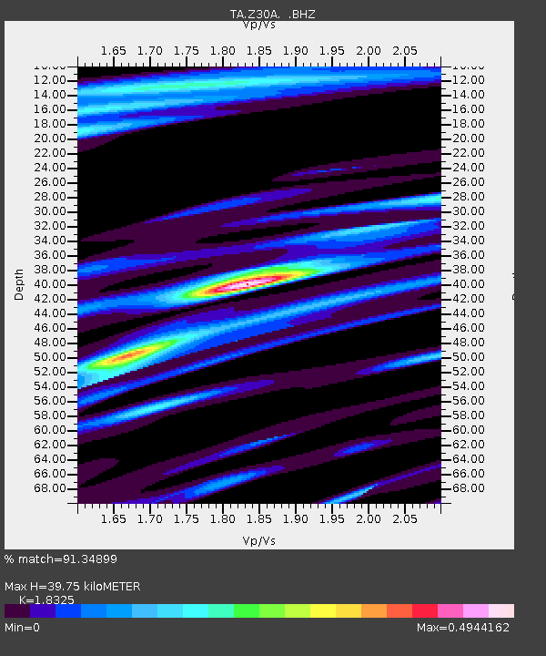
| Estimated Moho Depth: |
39.75 km |
| Estimated Crust Vp/Vs: |
1.83 |
| Assumed Crust Vp: |
6.426 km/s |
| Estimated Crust Vs: |
3.507 km/s |
| Estimated Crust Poisson's Ratio: |
0.29 |
|
| Radial Match: |
91.34899 % |
| Radial Bump: |
355 |
| Transverse Match: |
79.28801 % |
| Transverse Bump: |
400 |
| SOD ConfigId: |
2622 |
| Insert Time: |
2010-03-06 00:11:32.380 +0000 |
| GWidth: |
2.5 |
| Max Bumps: |
400 |
| Tol: |
0.001 |
|

Signal To Noise
| Channel | StoN | STA | LTA |
| TA:Z30A: :BHZ:20090730T20:17:53.849009Z | 6.601654 | 4.8470235E-7 | 7.342135E-8 |
| TA:Z30A: :BHN:20090730T20:17:53.849009Z | 1.48163 | 7.708105E-8 | 5.202449E-8 |
| TA:Z30A: :BHE:20090730T20:17:53.849009Z | 1.8384768 | 1.3317268E-7 | 7.2436414E-8 |
| Arrivals |
| Ps | 5.3 SECOND |
| PpPs | 17 SECOND |
| PsPs/PpSs | 22 SECOND |


