You are here: Home > Network List > TA - USArray Transportable Network (new EarthScope stations) Stations List
> Station N25K Chitina, Valdez-Cordova, AK, USA > Earthquake Result Viewer
N25K Chitina, Valdez-Cordova, AK, USA - Earthquake Result Viewer
| Earthquake location: |
Sulawesi, Indonesia |
| Earthquake latitude/longitude: |
-1.3/120.5 |
| Earthquake time(UTC): |
2017/05/29 (149) 14:35:20 GMT |
| Earthquake Depth: |
9.4 km |
| Earthquake Magnitude: |
6.6 Mww |
| Earthquake Catalog/Contributor: |
NEIC PDE/us |
|
| Network: |
TA USArray Transportable Network (new EarthScope stations) |
| Station: |
N25K Chitina, Valdez-Cordova, AK, USA |
| Lat/Lon: |
61.61 N/144.60 W |
| Elevation: |
1087 m |
|
| Distance: |
93.5 deg |
| Az: |
28.497 deg |
| Baz: |
273.728 deg |
| Ray Param: |
0.04125751 |
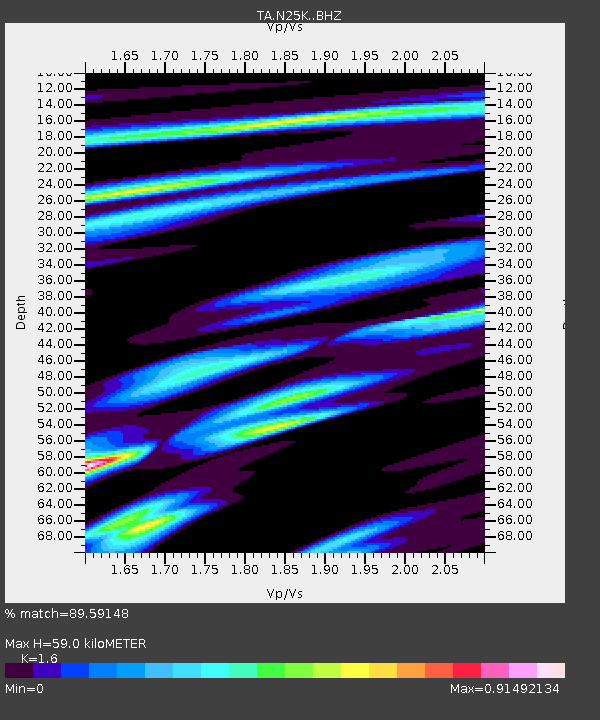
| Estimated Moho Depth: |
59.0 km |
| Estimated Crust Vp/Vs: |
1.60 |
| Assumed Crust Vp: |
6.566 km/s |
| Estimated Crust Vs: |
4.104 km/s |
| Estimated Crust Poisson's Ratio: |
0.18 |
|
| Radial Match: |
89.59148 % |
| Radial Bump: |
400 |
| Transverse Match: |
78.17973 % |
| Transverse Bump: |
400 |
| SOD ConfigId: |
13570011 |
| Insert Time: |
2019-04-28 02:36:16.517 +0000 |
| GWidth: |
2.5 |
| Max Bumps: |
400 |
| Tol: |
0.001 |
|
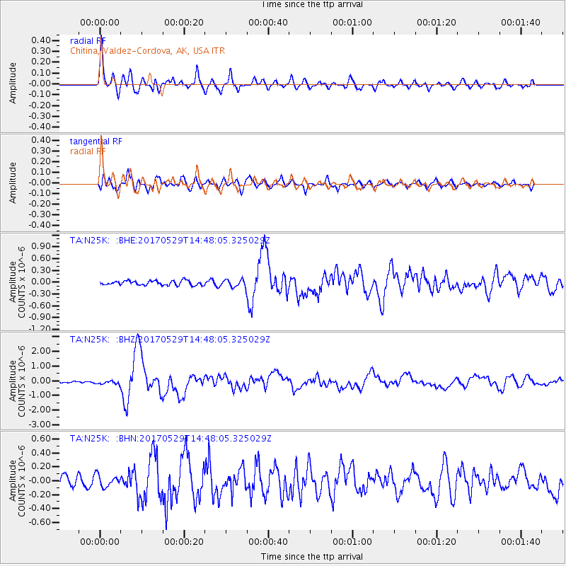
Signal To Noise
| Channel | StoN | STA | LTA |
| TA:N25K: :BHZ:20170529T14:48:05.325029Z | 2.1714287 | 1.2240879E-7 | 5.6372468E-8 |
| TA:N25K: :BHN:20170529T14:48:05.325029Z | 1.2909892 | 8.211481E-8 | 6.3606116E-8 |
| TA:N25K: :BHE:20170529T14:48:05.325029Z | 1.5681131 | 8.595244E-8 | 5.4812656E-8 |
| Arrivals |
| Ps | 5.5 SECOND |
| PpPs | 23 SECOND |
| PsPs/PpSs | 28 SECOND |


