You are here: Home > Network List > TA - USArray Transportable Network (new EarthScope stations) Stations List
> Station Z30A Sanderson Ranch, Post, TX, USA > Earthquake Result Viewer
Z30A Sanderson Ranch, Post, TX, USA - Earthquake Result Viewer
| Earthquake location: |
Easter Island Region |
| Earthquake latitude/longitude: |
-29.1/-112.3 |
| Earthquake time(UTC): |
2009/09/17 (260) 23:21:38 GMT |
| Earthquake Depth: |
10 km |
| Earthquake Magnitude: |
5.7 MB, 6.0 MS, 6.2 MW, 6.2 MW |
| Earthquake Catalog/Contributor: |
WHDF/NEIC |
|
| Network: |
TA USArray Transportable Network (new EarthScope stations) |
| Station: |
Z30A Sanderson Ranch, Post, TX, USA |
| Lat/Lon: |
33.29 N/101.13 W |
| Elevation: |
729 m |
|
| Distance: |
63.0 deg |
| Az: |
10.465 deg |
| Baz: |
190.935 deg |
| Ray Param: |
0.059872467 |
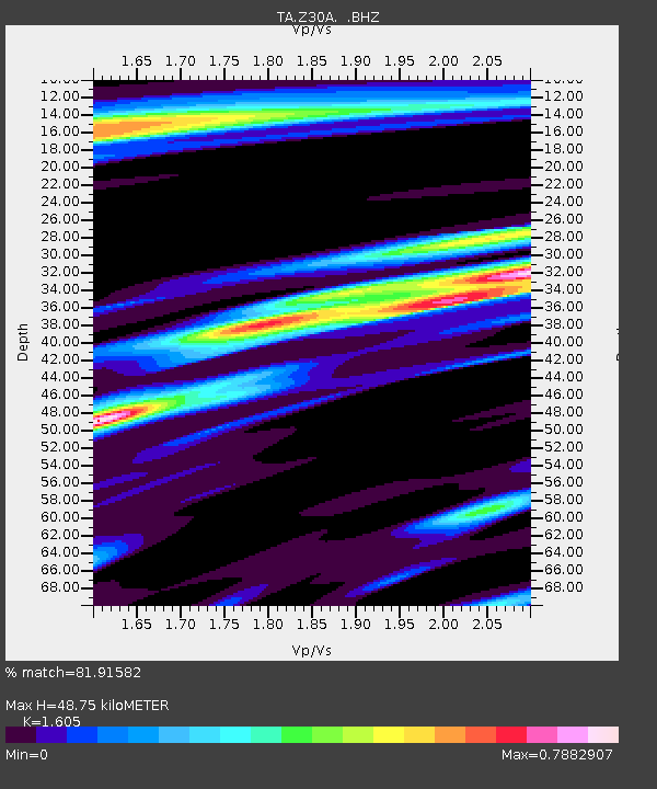
| Estimated Moho Depth: |
48.75 km |
| Estimated Crust Vp/Vs: |
1.61 |
| Assumed Crust Vp: |
6.426 km/s |
| Estimated Crust Vs: |
4.004 km/s |
| Estimated Crust Poisson's Ratio: |
0.18 |
|
| Radial Match: |
81.91582 % |
| Radial Bump: |
384 |
| Transverse Match: |
61.452545 % |
| Transverse Bump: |
400 |
| SOD ConfigId: |
2622 |
| Insert Time: |
2010-03-06 00:11:49.228 +0000 |
| GWidth: |
2.5 |
| Max Bumps: |
400 |
| Tol: |
0.001 |
|

Signal To Noise
| Channel | StoN | STA | LTA |
| TA:Z30A: :BHZ:20090917T23:31:34.175029Z | 3.666132 | 4.410761E-7 | 1.2031103E-7 |
| TA:Z30A: :BHN:20090917T23:31:34.175029Z | 2.6399174 | 2.3844802E-7 | 9.032404E-8 |
| TA:Z30A: :BHE:20090917T23:31:34.175029Z | 0.5042378 | 5.6646595E-8 | 1.1234104E-7 |
| Arrivals |
| Ps | 4.8 SECOND |
| PpPs | 19 SECOND |
| PsPs/PpSs | 24 SECOND |


