You are here: Home > Network List > TA - USArray Transportable Network (new EarthScope stations) Stations List
> Station Q19K Cape Douglas, AK, USA > Earthquake Result Viewer
Q19K Cape Douglas, AK, USA - Earthquake Result Viewer
| Earthquake location: |
Sulawesi, Indonesia |
| Earthquake latitude/longitude: |
-1.3/120.5 |
| Earthquake time(UTC): |
2017/05/29 (149) 14:35:20 GMT |
| Earthquake Depth: |
9.4 km |
| Earthquake Magnitude: |
6.6 Mww |
| Earthquake Catalog/Contributor: |
NEIC PDE/us |
|
| Network: |
TA USArray Transportable Network (new EarthScope stations) |
| Station: |
Q19K Cape Douglas, AK, USA |
| Lat/Lon: |
58.93 N/153.64 W |
| Elevation: |
631 m |
|
| Distance: |
88.9 deg |
| Az: |
31.158 deg |
| Baz: |
265.823 deg |
| Ray Param: |
0.042215526 |
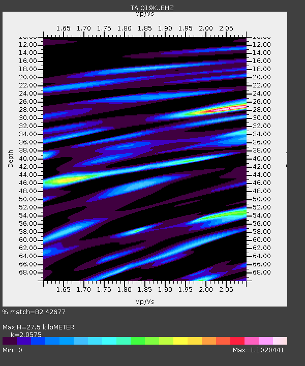
| Estimated Moho Depth: |
27.5 km |
| Estimated Crust Vp/Vs: |
2.06 |
| Assumed Crust Vp: |
5.989 km/s |
| Estimated Crust Vs: |
2.911 km/s |
| Estimated Crust Poisson's Ratio: |
0.35 |
|
| Radial Match: |
82.42677 % |
| Radial Bump: |
400 |
| Transverse Match: |
77.92054 % |
| Transverse Bump: |
400 |
| SOD ConfigId: |
13570011 |
| Insert Time: |
2019-04-28 02:36:27.482 +0000 |
| GWidth: |
2.5 |
| Max Bumps: |
400 |
| Tol: |
0.001 |
|

Signal To Noise
| Channel | StoN | STA | LTA |
| TA:Q19K: :BHZ:20170529T14:47:44.450029Z | 7.5419345 | 1.1815948E-6 | 1.5667E-7 |
| TA:Q19K: :BHN:20170529T14:47:44.450029Z | 1.2659454 | 2.7001676E-7 | 2.1329258E-7 |
| TA:Q19K: :BHE:20170529T14:47:44.450029Z | 1.8102622 | 6.344345E-7 | 3.5046554E-7 |
| Arrivals |
| Ps | 4.9 SECOND |
| PpPs | 14 SECOND |
| PsPs/PpSs | 19 SECOND |


