You are here: Home > Network List > TA - USArray Transportable Network (new EarthScope stations) Stations List
> Station Z30A Sanderson Ranch, Post, TX, USA > Earthquake Result Viewer
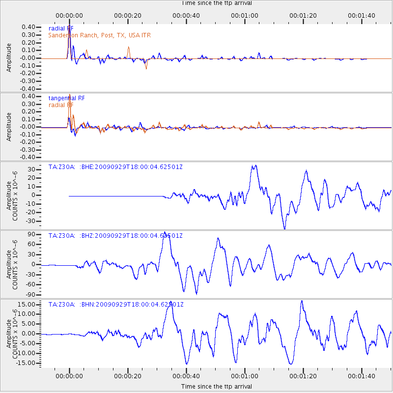
Z30A Sanderson Ranch, Post, TX, USA - Earthquake Result Viewer
| Earthquake location: |
Samoa Islands Region |
| Earthquake latitude/longitude: |
-15.5/-172.1 |
| Earthquake time(UTC): |
2009/09/29 (272) 17:48:10 GMT |
| Earthquake Depth: |
18 km |
| Earthquake Magnitude: |
7.1 MB, 8.1 MS, 8.1 MW, 8.0 MW |
| Earthquake Catalog/Contributor: |
WHDF/NEIC |
|
| Network: |
TA USArray Transportable Network (new EarthScope stations) |
| Station: |
Z30A Sanderson Ranch, Post, TX, USA |
| Lat/Lon: |
33.29 N/101.13 W |
| Elevation: |
729 m |
|
| Distance: |
83.2 deg |
| Az: |
52.886 deg |
| Baz: |
246.619 deg |
| Ray Param: |
0.046343464 |
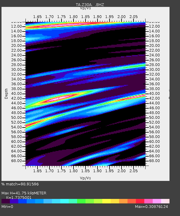
| Estimated Moho Depth: |
41.75 km |
| Estimated Crust Vp/Vs: |
1.74 |
| Assumed Crust Vp: |
6.426 km/s |
| Estimated Crust Vs: |
3.698 km/s |
| Estimated Crust Poisson's Ratio: |
0.25 |
|
| Radial Match: |
98.91596 % |
| Radial Bump: |
332 |
| Transverse Match: |
98.060135 % |
| Transverse Bump: |
374 |
| SOD ConfigId: |
2622 |
| Insert Time: |
2010-03-06 00:11:52.043 +0000 |
| GWidth: |
2.5 |
| Max Bumps: |
400 |
| Tol: |
0.001 |
|
Signal To Noise
| Channel | StoN | STA | LTA |
| TA:Z30A: :BHZ:20090929T18:00:04.62501Z | 17.031641 | 3.4996951E-6 | 2.0548197E-7 |
| TA:Z30A: :BHN:20090929T18:00:04.62501Z | 3.349812 | 3.586239E-7 | 1.0705792E-7 |
| TA:Z30A: :BHE:20090929T18:00:04.62501Z | 14.064453 | 1.1227372E-6 | 7.9828006E-8 |
| Arrivals |
| Ps | 4.9 SECOND |
| PpPs | 17 SECOND |
| PsPs/PpSs | 22 SECOND |


