You are here: Home > Network List > TA - USArray Transportable Network (new EarthScope stations) Stations List
> Station Z30A Sanderson Ranch, Post, TX, USA > Earthquake Result Viewer
Z30A Sanderson Ranch, Post, TX, USA - Earthquake Result Viewer

| Earthquake location: |
Azores Islands Region |
| Earthquake latitude/longitude: |
36.2/-33.9 |
| Earthquake time(UTC): |
2009/11/04 (308) 18:41:44 GMT |
| Earthquake Depth: |
10 km |
| Earthquake Magnitude: |
5.7 MB, 5.6 MS, 5.9 MW, 5.8 MW |
| Earthquake Catalog/Contributor: |
WHDF/NEIC |
|
| Network: |
TA USArray Transportable Network (new EarthScope stations) |
| Station: |
Z30A Sanderson Ranch, Post, TX, USA |
| Lat/Lon: |
33.29 N/101.13 W |
| Elevation: |
729 m |
|
| Distance: |
54.3 deg |
| Az: |
288.058 deg |
| Baz: |
66.724 deg |
| Ray Param: |
0.06550837 |
| Estimated Moho Depth: |
24.75 km |
| Estimated Crust Vp/Vs: |
1.93 |
| Assumed Crust Vp: |
6.426 km/s |
| Estimated Crust Vs: |
3.33 km/s |
| Estimated Crust Poisson's Ratio: |
0.32 |
|
| Radial Match: |
80.8217 % |
| Radial Bump: |
292 |
| Transverse Match: |
64.10837 % |
| Transverse Bump: |
400 |
| SOD ConfigId: |
2622 |
| Insert Time: |
2010-03-06 00:11:59.828 +0000 |
| GWidth: |
2.5 |
| Max Bumps: |
400 |
| Tol: |
0.001 |
|
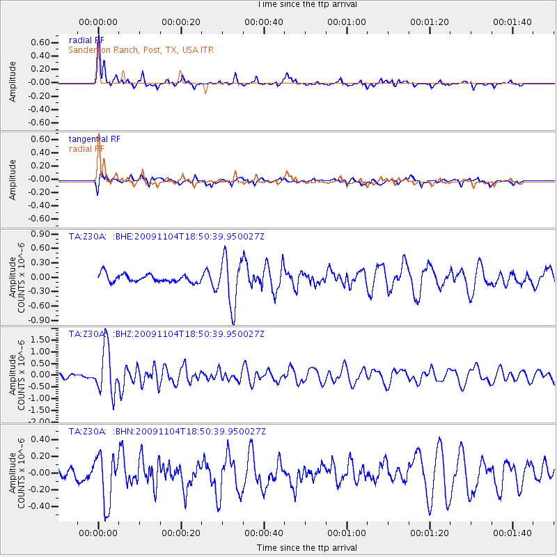
Signal To Noise
| Channel | StoN | STA | LTA |
| TA:Z30A: :BHZ:20091104T18:50:39.950027Z | 11.122499 | 1.0109536E-6 | 9.089266E-8 |
| TA:Z30A: :BHN:20091104T18:50:39.950027Z | 2.9742014 | 3.0253804E-7 | 1.01720765E-7 |
| TA:Z30A: :BHE:20091104T18:50:39.950027Z | 6.250247 | 5.0792767E-7 | 8.126521E-8 |
| Arrivals |
| Ps | 3.8 SECOND |
| PpPs | 11 SECOND |
| PsPs/PpSs | 15 SECOND |


