You are here: Home > Network List > TA - USArray Transportable Network (new EarthScope stations) Stations List
> Station 833A Chaparral WMA, Artesia Wells, TX, USA > Earthquake Result Viewer
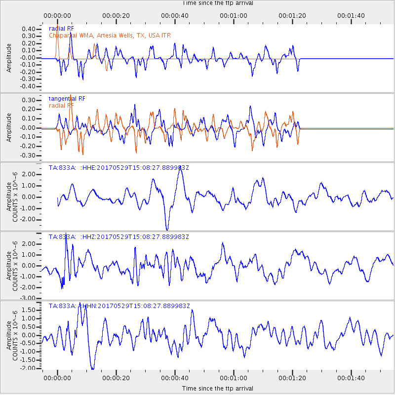
833A Chaparral WMA, Artesia Wells, TX, USA - Earthquake Result Viewer
*The percent match for this event was below the threshold and hence no stack was calculated.
| Earthquake location: |
S. Chile-Argentina Border Region |
| Earthquake latitude/longitude: |
-37.3/-71.6 |
| Earthquake time(UTC): |
2017/05/29 (149) 14:57:54 GMT |
| Earthquake Depth: |
87 km |
| Earthquake Magnitude: |
5.7 Mwr |
| Earthquake Catalog/Contributor: |
NEIC PDE/us |
|
| Network: |
TA USArray Transportable Network (new EarthScope stations) |
| Station: |
833A Chaparral WMA, Artesia Wells, TX, USA |
| Lat/Lon: |
28.32 N/99.39 W |
| Elevation: |
171 m |
|
| Distance: |
70.3 deg |
| Az: |
334.133 deg |
| Baz: |
156.772 deg |
| Ray Param: |
$rayparam |
*The percent match for this event was below the threshold and hence was not used in the summary stack. |
|
| Radial Match: |
49.85829 % |
| Radial Bump: |
240 |
| Transverse Match: |
53.280136 % |
| Transverse Bump: |
305 |
| SOD ConfigId: |
13570011 |
| Insert Time: |
2019-04-28 02:41:59.436 +0000 |
| GWidth: |
2.5 |
| Max Bumps: |
400 |
| Tol: |
0.001 |
|
Signal To Noise
| Channel | StoN | STA | LTA |
| TA:833A: :HHZ:20170529T15:08:27.889983Z | 2.8139567 | 1.2678204E-6 | 4.5054722E-7 |
| TA:833A: :HHN:20170529T15:08:27.889983Z | 0.9293073 | 5.565586E-7 | 5.988962E-7 |
| TA:833A: :HHE:20170529T15:08:27.889983Z | 1.8426046 | 8.458562E-7 | 4.5905463E-7 |
| Arrivals |
| Ps | |
| PpPs | |
| PsPs/PpSs | |


