You are here: Home > Network List > TA - USArray Transportable Network (new EarthScope stations) Stations List
> Station 109C Camp Elliot, Mirimar, CA, USA > Earthquake Result Viewer
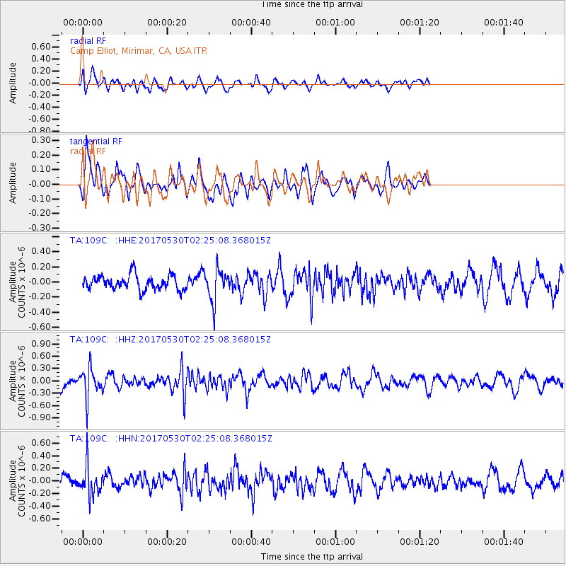
109C Camp Elliot, Mirimar, CA, USA - Earthquake Result Viewer
*The percent match for this event was below the threshold and hence no stack was calculated.
| Earthquake location: |
Kenai Peninsula, Alaska |
| Earthquake latitude/longitude: |
60.8/-151.8 |
| Earthquake time(UTC): |
2017/05/30 (150) 02:18:45 GMT |
| Earthquake Depth: |
78 km |
| Earthquake Magnitude: |
5.2 Mww |
| Earthquake Catalog/Contributor: |
NEIC PDE/ak |
|
| Network: |
TA USArray Transportable Network (new EarthScope stations) |
| Station: |
109C Camp Elliot, Mirimar, CA, USA |
| Lat/Lon: |
32.89 N/117.11 W |
| Elevation: |
150 m |
|
| Distance: |
35.9 deg |
| Az: |
125.212 deg |
| Baz: |
331.602 deg |
| Ray Param: |
$rayparam |
*The percent match for this event was below the threshold and hence was not used in the summary stack. |
|
| Radial Match: |
42.585423 % |
| Radial Bump: |
400 |
| Transverse Match: |
63.218803 % |
| Transverse Bump: |
400 |
| SOD ConfigId: |
13570011 |
| Insert Time: |
2019-04-28 02:50:35.613 +0000 |
| GWidth: |
2.5 |
| Max Bumps: |
400 |
| Tol: |
0.001 |
|
Signal To Noise
| Channel | StoN | STA | LTA |
| TA:109C: :HHZ:20170530T02:25:08.368015Z | 1.813334 | 3.5872327E-7 | 1.9782526E-7 |
| TA:109C: :HHN:20170530T02:25:08.368015Z | 2.139442 | 2.3245703E-7 | 1.0865311E-7 |
| TA:109C: :HHE:20170530T02:25:08.368015Z | 2.3087847 | 2.1860073E-7 | 9.4682164E-8 |
| Arrivals |
| Ps | |
| PpPs | |
| PsPs/PpSs | |


