You are here: Home > Network List > AK - Alaska Regional Network Stations List
> Station CUT Chulitna, AK, USA > Earthquake Result Viewer
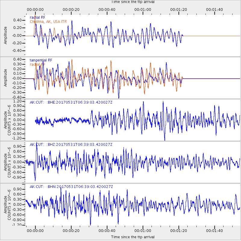
CUT Chulitna, AK, USA - Earthquake Result Viewer
*The percent match for this event was below the threshold and hence no stack was calculated.
| Earthquake location: |
Mariana Islands |
| Earthquake latitude/longitude: |
19.1/145.9 |
| Earthquake time(UTC): |
2017/05/31 (151) 06:29:32 GMT |
| Earthquake Depth: |
121 km |
| Earthquake Magnitude: |
5.4 Mww |
| Earthquake Catalog/Contributor: |
NEIC PDE/us |
|
| Network: |
AK Alaska Regional Network |
| Station: |
CUT Chulitna, AK, USA |
| Lat/Lon: |
62.41 N/150.26 W |
| Elevation: |
574 m |
|
| Distance: |
61.2 deg |
| Az: |
28.495 deg |
| Baz: |
255.665 deg |
| Ray Param: |
$rayparam |
*The percent match for this event was below the threshold and hence was not used in the summary stack. |
|
| Radial Match: |
64.27798 % |
| Radial Bump: |
400 |
| Transverse Match: |
65.87134 % |
| Transverse Bump: |
400 |
| SOD ConfigId: |
13570011 |
| Insert Time: |
2019-04-28 02:55:02.113 +0000 |
| GWidth: |
2.5 |
| Max Bumps: |
400 |
| Tol: |
0.001 |
|
Signal To Noise
| Channel | StoN | STA | LTA |
| AK:CUT: :BHZ:20170531T06:39:03.420027Z | 4.706424 | 4.768916E-7 | 1.013278E-7 |
| AK:CUT: :BHN:20170531T06:39:03.420027Z | 1.750453 | 2.6693232E-7 | 1.5249329E-7 |
| AK:CUT: :BHE:20170531T06:39:03.420027Z | 2.305192 | 2.7404008E-7 | 1.18879505E-7 |
| Arrivals |
| Ps | |
| PpPs | |
| PsPs/PpSs | |


