You are here: Home > Network List > TA - USArray Transportable Network (new EarthScope stations) Stations List
> Station Y32A R-V Farms, Vernon, TX, USA > Earthquake Result Viewer
Y32A R-V Farms, Vernon, TX, USA - Earthquake Result Viewer
| Earthquake location: |
Near S. Coast Of Honshu, Japan |
| Earthquake latitude/longitude: |
33.2/137.9 |
| Earthquake time(UTC): |
2009/08/09 (221) 10:55:55 GMT |
| Earthquake Depth: |
297 km |
| Earthquake Magnitude: |
6.5 MB, 7.1 MW, 7.1 MW |
| Earthquake Catalog/Contributor: |
WHDF/NEIC |
|
| Network: |
TA USArray Transportable Network (new EarthScope stations) |
| Station: |
Y32A R-V Farms, Vernon, TX, USA |
| Lat/Lon: |
34.00 N/99.44 W |
| Elevation: |
412 m |
|
| Distance: |
94.2 deg |
| Az: |
44.553 deg |
| Baz: |
314.9 deg |
| Ray Param: |
0.04087028 |
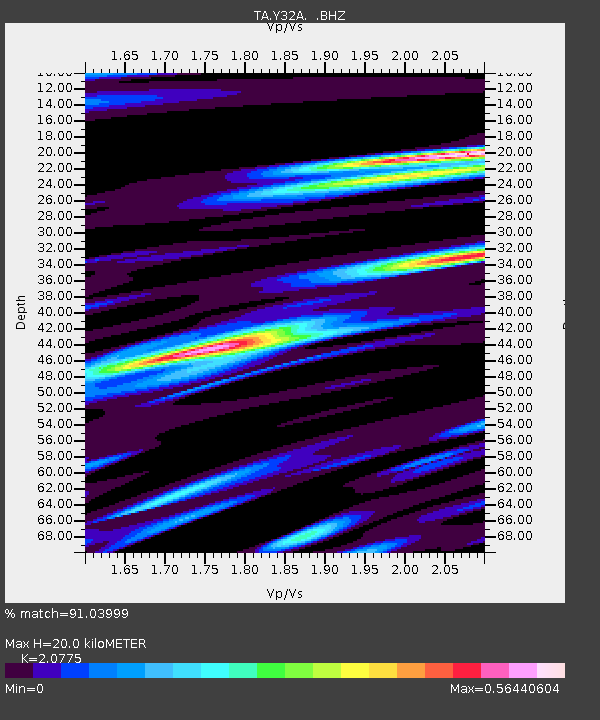
| Estimated Moho Depth: |
20.0 km |
| Estimated Crust Vp/Vs: |
2.08 |
| Assumed Crust Vp: |
6.315 km/s |
| Estimated Crust Vs: |
3.04 km/s |
| Estimated Crust Poisson's Ratio: |
0.35 |
|
| Radial Match: |
91.03999 % |
| Radial Bump: |
400 |
| Transverse Match: |
81.8788 % |
| Transverse Bump: |
400 |
| SOD ConfigId: |
2622 |
| Insert Time: |
2010-03-06 00:15:37.299 +0000 |
| GWidth: |
2.5 |
| Max Bumps: |
400 |
| Tol: |
0.001 |
|

Signal To Noise
| Channel | StoN | STA | LTA |
| TA:Y32A: :BHZ:20090809T11:08:09.425002Z | 45.608532 | 3.5755195E-6 | 7.839585E-8 |
| TA:Y32A: :BHN:20090809T11:08:09.425002Z | 8.056417 | 8.0789874E-7 | 1.0028015E-7 |
| TA:Y32A: :BHE:20090809T11:08:09.425002Z | 6.33394 | 6.955459E-7 | 1.09812525E-7 |
| Arrivals |
| Ps | 3.5 SECOND |
| PpPs | 9.6 SECOND |
| PsPs/PpSs | 13 SECOND |


