You are here: Home > Network List > AV - Alaska Volcano Observatory Stations List
> Station SPCR Ckakachatna River, Mount Spurr, Alaska > Earthquake Result Viewer
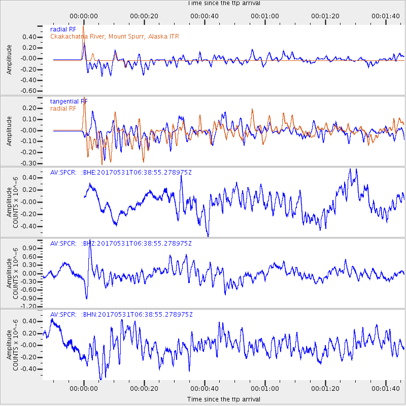
SPCR Ckakachatna River, Mount Spurr, Alaska - Earthquake Result Viewer
*The percent match for this event was below the threshold and hence no stack was calculated.
| Earthquake location: |
Mariana Islands |
| Earthquake latitude/longitude: |
19.1/145.9 |
| Earthquake time(UTC): |
2017/05/31 (151) 06:29:32 GMT |
| Earthquake Depth: |
121 km |
| Earthquake Magnitude: |
5.4 Mww |
| Earthquake Catalog/Contributor: |
NEIC PDE/us |
|
| Network: |
AV Alaska Volcano Observatory |
| Station: |
SPCR Ckakachatna River, Mount Spurr, Alaska |
| Lat/Lon: |
61.20 N/152.21 W |
| Elevation: |
984 m |
|
| Distance: |
60.0 deg |
| Az: |
29.564 deg |
| Baz: |
254.477 deg |
| Ray Param: |
$rayparam |
*The percent match for this event was below the threshold and hence was not used in the summary stack. |
|
| Radial Match: |
63.246788 % |
| Radial Bump: |
400 |
| Transverse Match: |
42.700657 % |
| Transverse Bump: |
400 |
| SOD ConfigId: |
13570011 |
| Insert Time: |
2019-04-28 02:56:27.711 +0000 |
| GWidth: |
2.5 |
| Max Bumps: |
400 |
| Tol: |
0.001 |
|
Signal To Noise
| Channel | StoN | STA | LTA |
| AV:SPCR: :BHZ:20170531T06:38:55.278975Z | 3.2264643 | 5.1135964E-7 | 1.5848916E-7 |
| AV:SPCR: :BHN:20170531T06:38:55.278975Z | 1.2270318 | 2.2252117E-7 | 1.8134914E-7 |
| AV:SPCR: :BHE:20170531T06:38:55.278975Z | 1.116778 | 1.8241006E-7 | 1.6333601E-7 |
| Arrivals |
| Ps | |
| PpPs | |
| PsPs/PpSs | |


