You are here: Home > Network List > TA - USArray Transportable Network (new EarthScope stations) Stations List
> Station Y32A R-V Farms, Vernon, TX, USA > Earthquake Result Viewer
Y32A R-V Farms, Vernon, TX, USA - Earthquake Result Viewer
| Earthquake location: |
Samoa Islands Region |
| Earthquake latitude/longitude: |
-15.4/-172.3 |
| Earthquake time(UTC): |
2009/10/19 (292) 22:49:38 GMT |
| Earthquake Depth: |
18 km |
| Earthquake Magnitude: |
6.2 MB, 5.7 MS, 6.0 MW, 5.9 MW |
| Earthquake Catalog/Contributor: |
WHDF/NEIC |
|
| Network: |
TA USArray Transportable Network (new EarthScope stations) |
| Station: |
Y32A R-V Farms, Vernon, TX, USA |
| Lat/Lon: |
34.00 N/99.44 W |
| Elevation: |
412 m |
|
| Distance: |
84.8 deg |
| Az: |
52.838 deg |
| Baz: |
247.739 deg |
| Ray Param: |
0.04518949 |
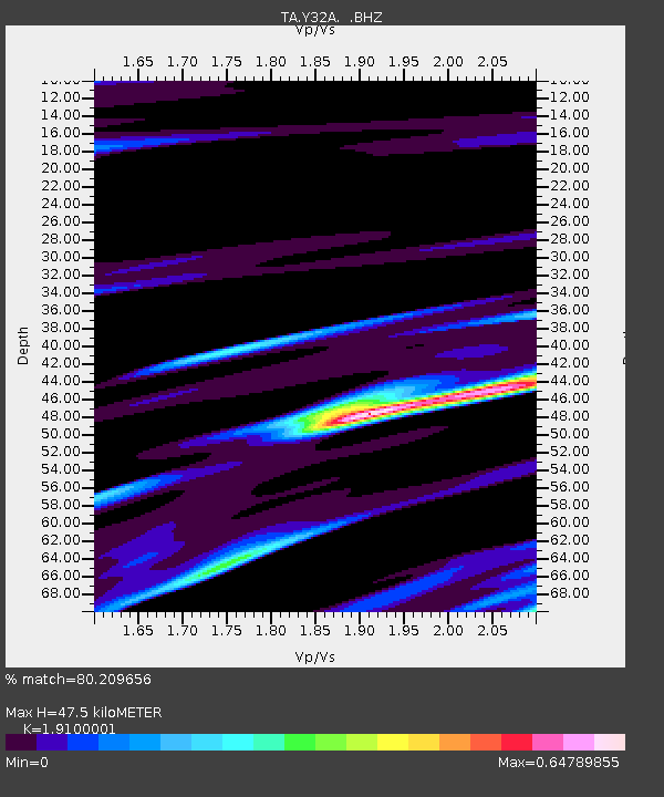
| Estimated Moho Depth: |
47.5 km |
| Estimated Crust Vp/Vs: |
1.91 |
| Assumed Crust Vp: |
6.315 km/s |
| Estimated Crust Vs: |
3.306 km/s |
| Estimated Crust Poisson's Ratio: |
0.31 |
|
| Radial Match: |
80.209656 % |
| Radial Bump: |
400 |
| Transverse Match: |
64.79576 % |
| Transverse Bump: |
400 |
| SOD ConfigId: |
2622 |
| Insert Time: |
2010-03-06 00:15:54.761 +0000 |
| GWidth: |
2.5 |
| Max Bumps: |
400 |
| Tol: |
0.001 |
|
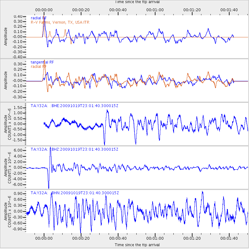
Signal To Noise
| Channel | StoN | STA | LTA |
| TA:Y32A: :BHZ:20091019T23:01:40.300015Z | 12.502634 | 3.032325E-6 | 2.425349E-7 |
| TA:Y32A: :BHN:20091019T23:01:40.300015Z | 1.8452941 | 4.5329335E-7 | 2.456483E-7 |
| TA:Y32A: :BHE:20091019T23:01:40.300015Z | 3.1411264 | 7.994024E-7 | 2.5449546E-7 |
| Arrivals |
| Ps | 7.0 SECOND |
| PpPs | 21 SECOND |
| PsPs/PpSs | 28 SECOND |


