You are here: Home > Network List > CI - Caltech Regional Seismic Network Stations List
> Station MPP McPhearson Peak > Earthquake Result Viewer
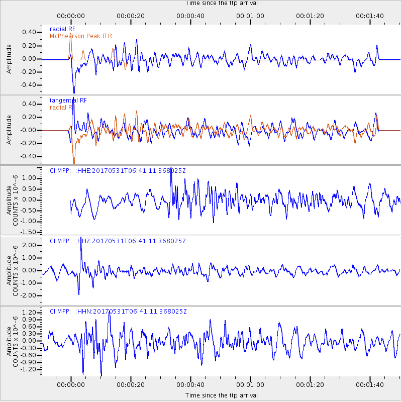
MPP McPhearson Peak - Earthquake Result Viewer
*The percent match for this event was below the threshold and hence no stack was calculated.
| Earthquake location: |
Mariana Islands |
| Earthquake latitude/longitude: |
19.1/145.9 |
| Earthquake time(UTC): |
2017/05/31 (151) 06:29:32 GMT |
| Earthquake Depth: |
121 km |
| Earthquake Magnitude: |
5.4 Mww |
| Earthquake Catalog/Contributor: |
NEIC PDE/us |
|
| Network: |
CI Caltech Regional Seismic Network |
| Station: |
MPP McPhearson Peak |
| Lat/Lon: |
34.89 N/119.81 W |
| Elevation: |
1739 m |
|
| Distance: |
82.7 deg |
| Az: |
55.726 deg |
| Baz: |
288.089 deg |
| Ray Param: |
$rayparam |
*The percent match for this event was below the threshold and hence was not used in the summary stack. |
|
| Radial Match: |
60.88114 % |
| Radial Bump: |
400 |
| Transverse Match: |
61.854786 % |
| Transverse Bump: |
400 |
| SOD ConfigId: |
13570011 |
| Insert Time: |
2019-04-28 02:57:25.506 +0000 |
| GWidth: |
2.5 |
| Max Bumps: |
400 |
| Tol: |
0.001 |
|
Signal To Noise
| Channel | StoN | STA | LTA |
| CI:MPP: :HHZ:20170531T06:41:11.368025Z | 4.423422 | 8.588107E-7 | 1.9415076E-7 |
| CI:MPP: :HHN:20170531T06:41:11.368025Z | 1.7872905 | 4.0118053E-7 | 2.2446297E-7 |
| CI:MPP: :HHE:20170531T06:41:11.368025Z | 1.6084442 | 4.929201E-7 | 3.0645768E-7 |
| Arrivals |
| Ps | |
| PpPs | |
| PsPs/PpSs | |


