You are here: Home > Network List > G - GEOSCOPE Stations List
> Station CLF Chambon la Foret observatory, France > Earthquake Result Viewer
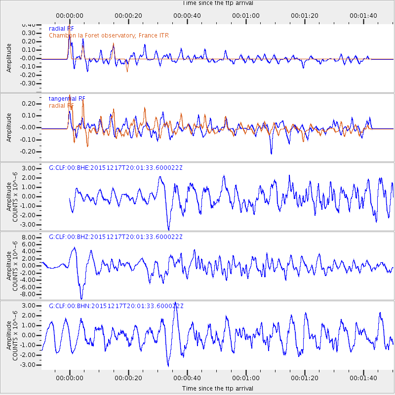
CLF Chambon la Foret observatory, France - Earthquake Result Viewer
*The percent match for this event was below the threshold and hence no stack was calculated.
| Earthquake location: |
Near Coast Of Chiapas, Mexico |
| Earthquake latitude/longitude: |
15.9/-93.4 |
| Earthquake time(UTC): |
2015/12/17 (351) 19:49:54 GMT |
| Earthquake Depth: |
97 km |
| Earthquake Magnitude: |
6.4 MWB, 6.6 MI |
| Earthquake Catalog/Contributor: |
NEIC PDE/NEIC COMCAT |
|
| Network: |
G GEOSCOPE |
| Station: |
CLF Chambon la Foret observatory, France |
| Lat/Lon: |
48.03 N/2.26 E |
| Elevation: |
145 m |
|
| Distance: |
82.1 deg |
| Az: |
42.407 deg |
| Baz: |
284.822 deg |
| Ray Param: |
$rayparam |
*The percent match for this event was below the threshold and hence was not used in the summary stack. |
|
| Radial Match: |
76.32419 % |
| Radial Bump: |
400 |
| Transverse Match: |
63.797283 % |
| Transverse Bump: |
400 |
| SOD ConfigId: |
1259291 |
| Insert Time: |
2015-12-31 20:12:34.993 +0000 |
| GWidth: |
2.5 |
| Max Bumps: |
400 |
| Tol: |
0.001 |
|
Signal To Noise
| Channel | StoN | STA | LTA |
| G:CLF:00:BHZ:20151217T20:01:33.600022Z | 6.393929 | 4.8327606E-6 | 7.558358E-7 |
| G:CLF:00:BHN:20151217T20:01:33.600022Z | 1.4700919 | 1.163466E-6 | 7.9142393E-7 |
| G:CLF:00:BHE:20151217T20:01:33.600022Z | 3.3862922 | 1.8307873E-6 | 5.4064657E-7 |
| Arrivals |
| Ps | |
| PpPs | |
| PsPs/PpSs | |


